
- PV to only allow access to 2000 routes out of 8700
- Trackside, Bleachers, Valley of the Giants & Snake Pit bouldering added to banned list
- Climbing permits to be introduced – and they can be revoked at PVs discretion
- Ban on white chalk – coloured ok?
- Bouldering mats to be banned at most “open” areas
- No new areas to be developed & no new bolts
- Huge new bans on bouldering in remote areas
This article is being updated throughout the next couple of days as we delve deeper into the documents. Last update was 4pm 12 November 2020.
This week was the big reveal of the much anticipated Greater Gariwerd Landscape Draft Management Plan – the document set to control the future of rock climbing in one of the world’s best climbing areas for at least the next 15 years. The plan details radical proposals including permanent bans on the majority of roped climbing areas, compulsory climbing permits and the decimation of bouldering full stop.
This plan has been more than 18 months in the making and Parks Victoria have constantly told climbers to wait until this draft plan is made public before giving feedback. We have also been told that this process will “take time” and we need to “listen”. Unfortunately time is up.
THIS IS IT. THE TIME TO ACT IS NOW.
Parks Victoria is giving the community 10 measly weeks to give them feedback on this plan – the deadline is Sunday 24 January 2021. Put that date in your calendar – don’t put this off. If you care about the future of rock climbing or bouldering in the Grampians we really need you to go to the Engage Victoria website and leave your feedback. It can be done as a simple survey or write them an email – parkplan@parks.vic.gov.au . You can agree or disagree with all or parts of their plan – the most important thing is they get lots of feedback from climbers.
The Master Plan
There are several documents to peruse – the actual Draft Management Plan, a supplemental document that just focuses on climbing titled Overview of Rock Climbing Proposals (because we are special), a document about how they picked what to ban Rock Climbing Decisions Making Frame for the Gariwerd Landscape and then several other related documents including an Archaeological Field Survey of Climbing Areas (from old mate Ben Gunn no doubt) and Gariwerd Aboriginal Cultural Heritage Assessments. There is a lot to unpack…
Let’s start with Park Victoria’s basic overview. Their draft plan proposes a new approach to climbing in the park while protecting important natural and cultural values. The approach outlined in the draft plan is:
• To climb in the designated areas, climbers will be asked to obtain a climbing permit (at no cost and valid for one year). The purpose of this permit is to provide a mechanism to keep climbers updated about how and where they can climb in the landscape and to ensure everyone is aware of the conditions specific to climbing in the Gariwerd landscape.
• Once the plan is finalised no new climbing areas will be established.
• No fixed anchors can be made in the landscape without the consent of land managers. Temporary protection will be allowed.
• Use of coloured chalk only, not white chalk.
• Bouldering, and the use of bouldering mats, will only be allowed in some designated climbing areas if it is determined the potential impacts to natural and cultural values can be managed. [i.e. they have not listed these areas!]
• Bouldering will not be allowed in Remote and Natural Areas.
• Rock climbing and bouldering events and competitions will not be allowed in the landscape due to the higher number of users present at a location during a competition.
SPAs gone – now it’s “Designated Climbing Areas”
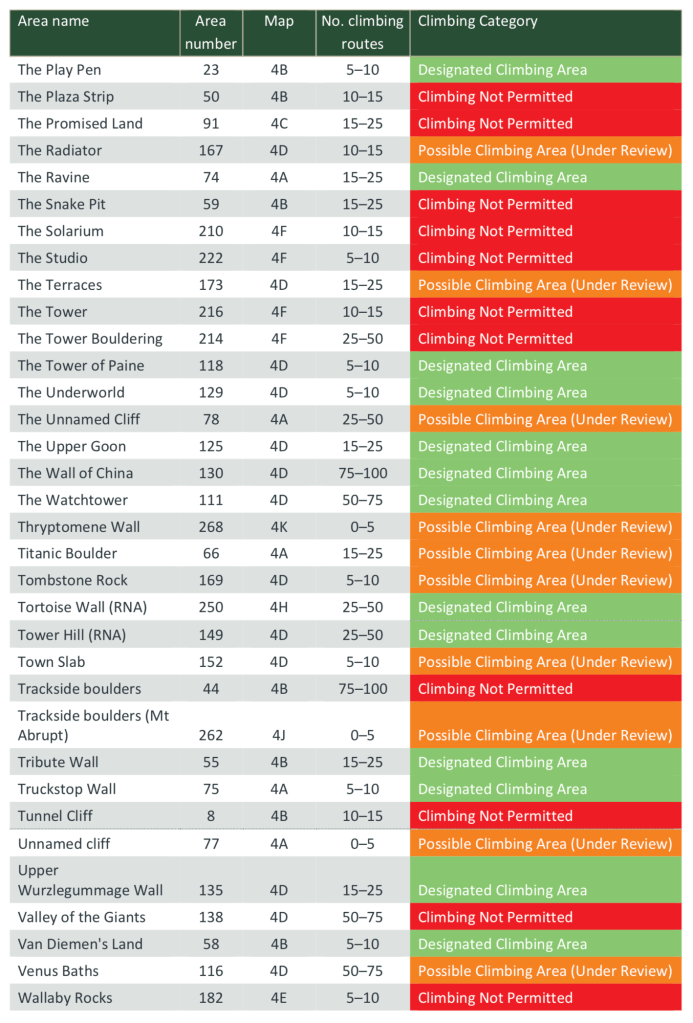
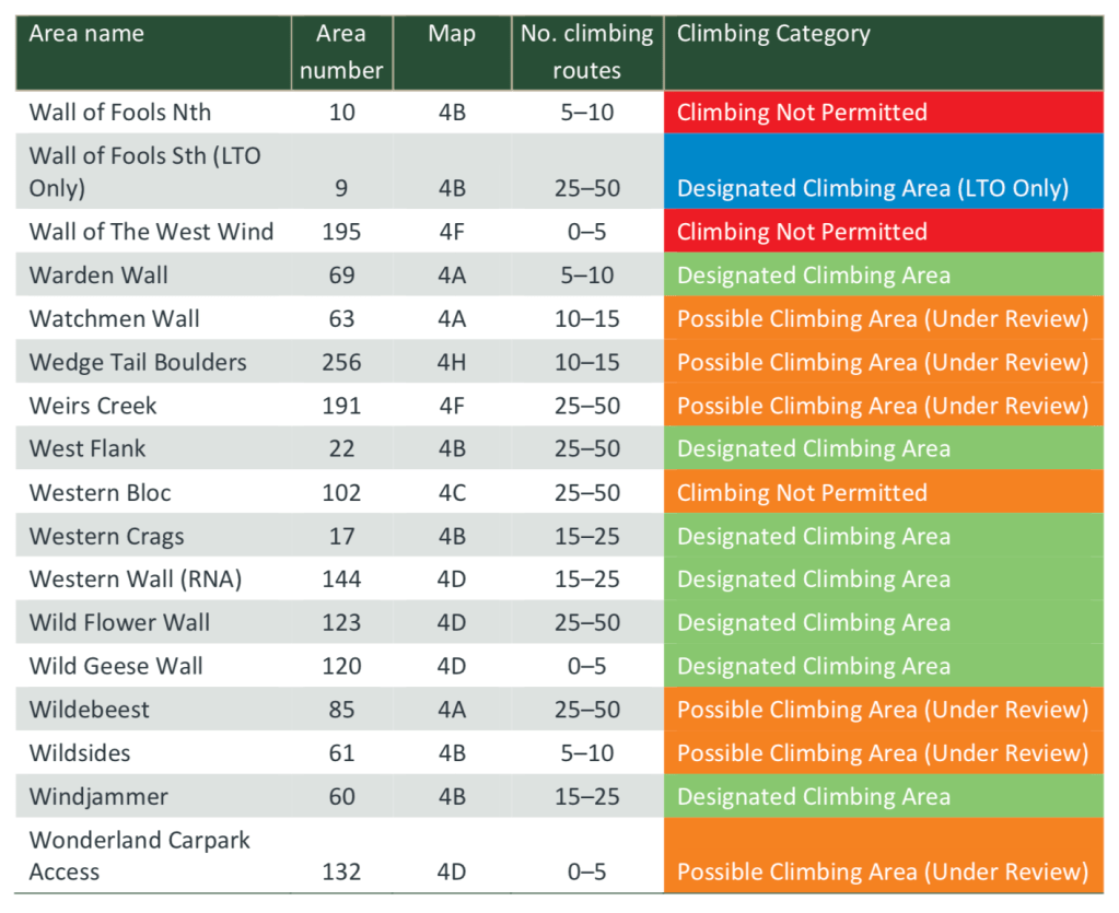
In short – Special Protection Areas are gone – instead each individual crag is being assessed and given a traffic light colour coding related to climbing access – green (climbing ok), red (permanent ban), orange (yet to be assessed) and blue (LTO only). To put it simply – if a crag hasn’t had the PV tick of approval – it is automatically banned. This suddenly makes a lot of areas off limits to climbers without PV having to lift a finger to apply for “determinations” to ban climbers at specific sites. Is this legal? We don’t know yet.
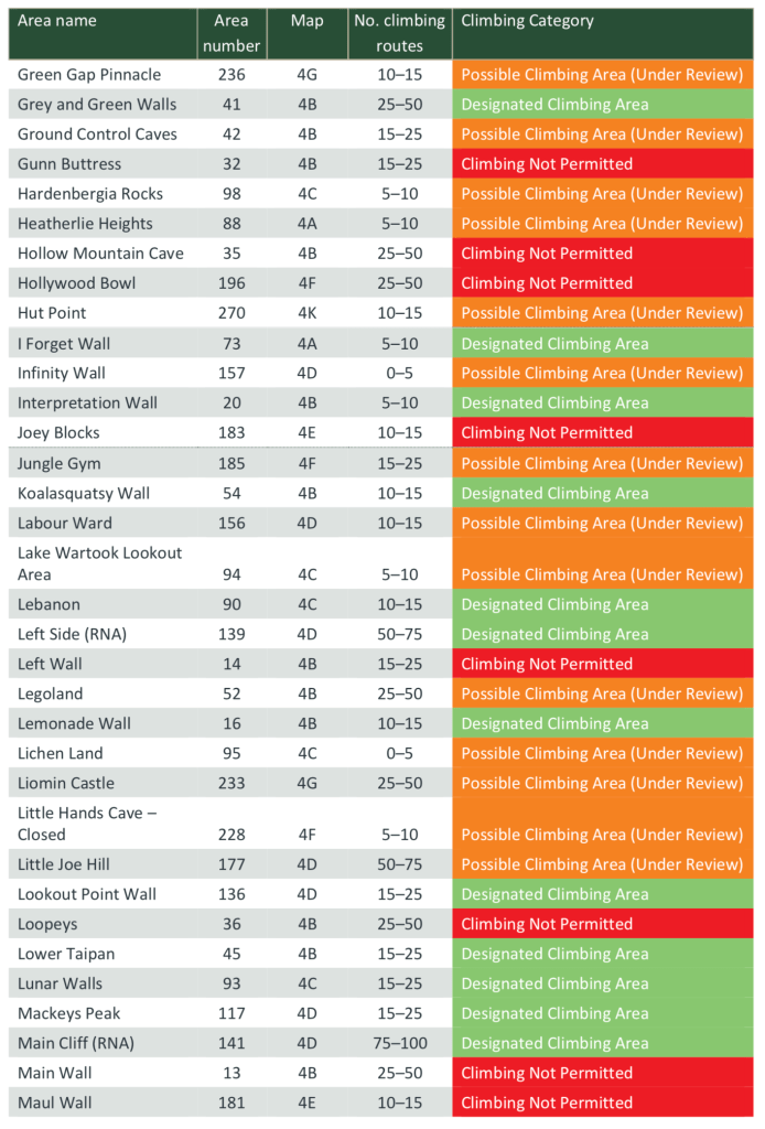
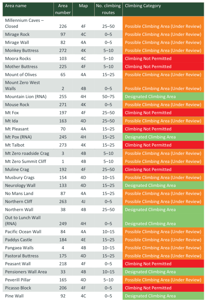
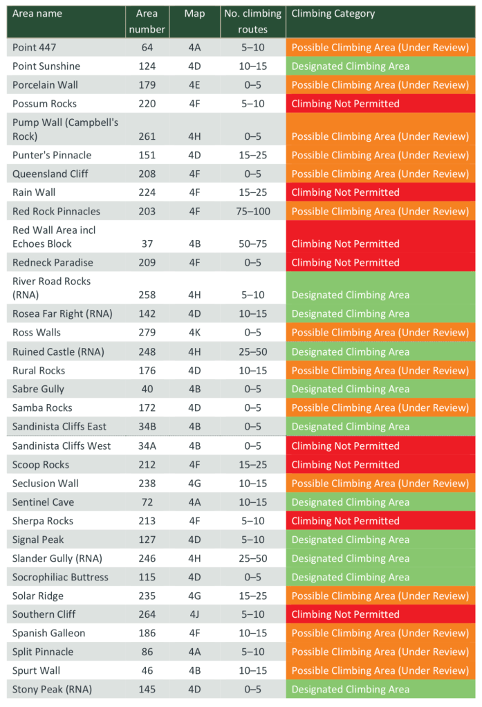
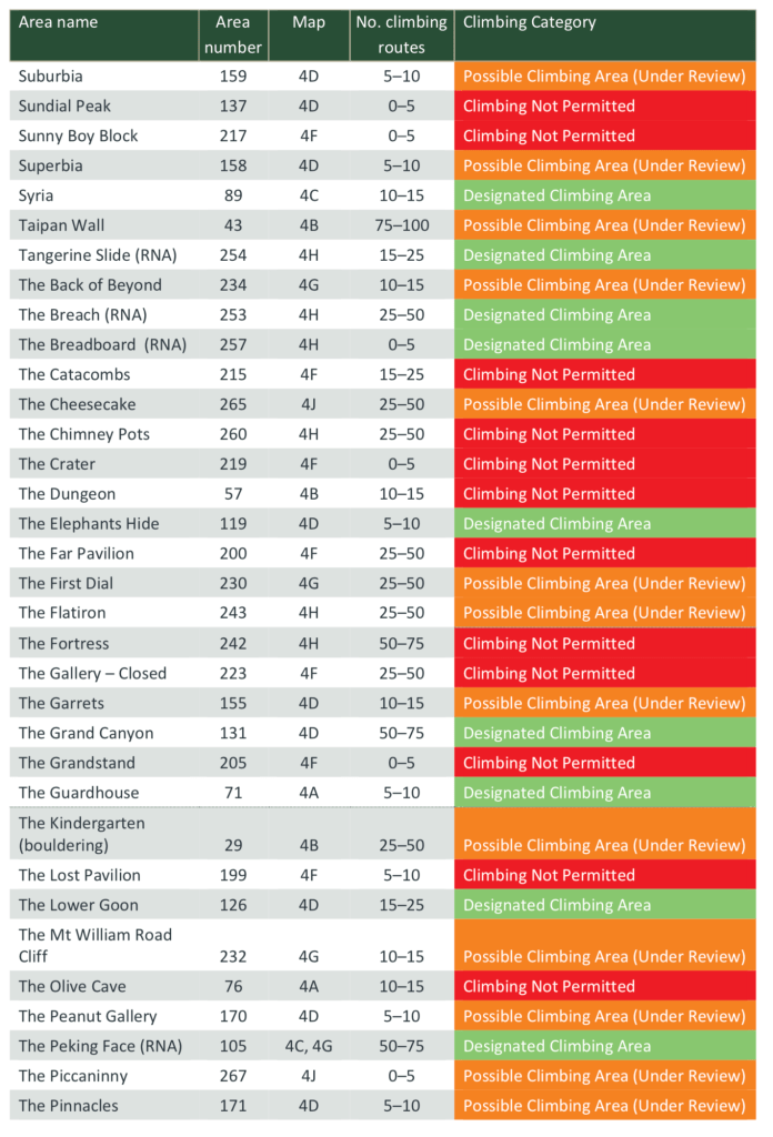
The numbers game – what crags are in and out?
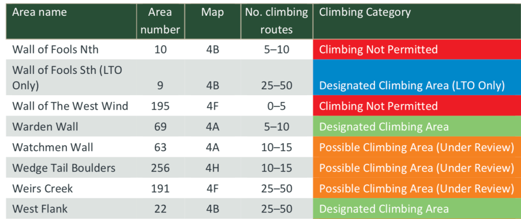
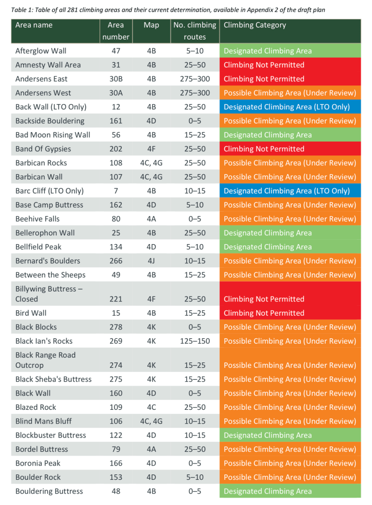
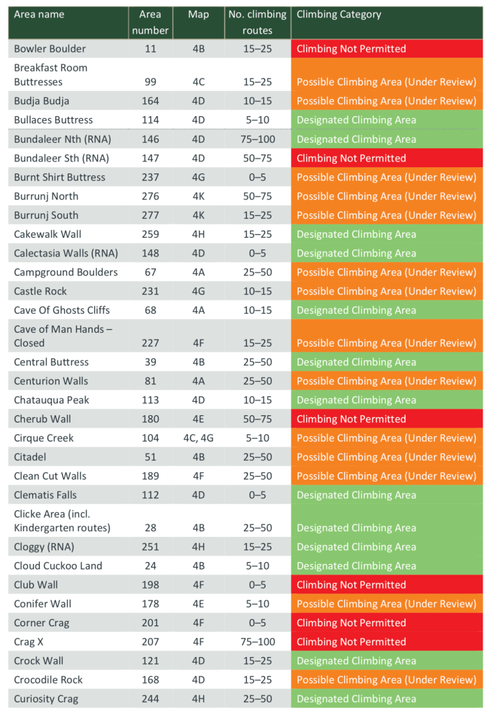
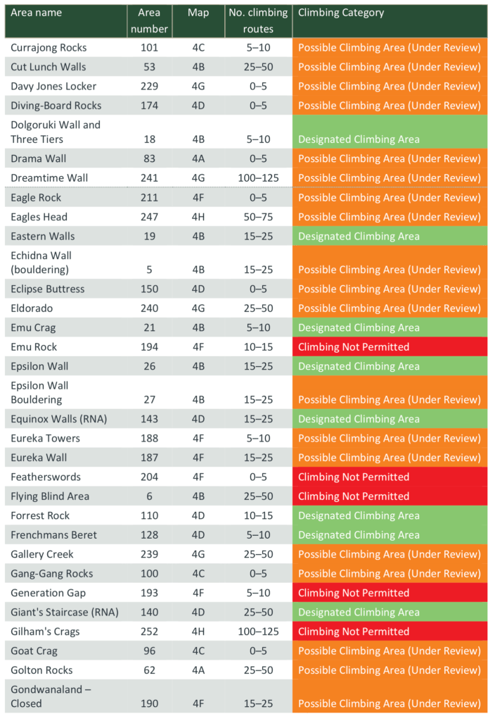
Parks Victoria defined 281 climbing areas across the Grampians and has made determinations for 155 of these 281 areas. The outcome was:
- 86 Designated Climbing Areas containing up to 2000 published climbing routes.
- 3 Designated Climbing Areas (LTO only), which will be accessible only through a Licensed Tour Operator (additional to the 86).
- 66 Climbing Not Permitted areas, where climbing is proposed to be excluded.
- The remaining 126 areas are currently designated Possible Climbing Areas. Depending on these results of assessments they may become Designated Climbing Areas. Parks Victoria will continue to seek funding to undertake the outstanding assessments as soon as possible.
Assessments on hold?
So it seems the assessment and categorizing of the remaining 126 areas (including very significant crags) is to be put on hold whilst PV try and rustle up some more extra cash from the government. Even worse – these areas that remain without an assessment and determination are automatically closed to climbing – the wording in PV’s document is “Rock climbing (including bouldering) will not be permitted in these areas until the relevant assessments and planning has taken place.” So anything marked in orange in the list above is a proper ban until PV can be bothered going through the assessment process – and that could result in a permanent ban. We have to ask – what’s in it for them to have more areas open? Nothing. So it’s no surprise that there is no timeline given for when funding will be arranged and further assessments will happen. The less areas PV has to manage the happier they will be. Climbers are to remain in limbo into the perceivable future whilst many of our most precious climbing areas remain closed. So much for a management plan that will solve the Grampians climbing access crisis hey.
Missing crags?
There is also the mysterious case of the missing crags – Parks Victoria appears to have forgotten about many major areas in the Grampians. We did a quick calculation and found over 1000 routes located at crags that PV doesn’t seem to even know exist – they are not listed in any of these new documents and unmarked on maps. And that was not even going into the tiny odd crags that only contain a handful of routes. Some of these missing areas are so large they have dedicated print guidebooks to them! We won’t list them here as it’s a bit of a touchy subject if they are to be sent to PV or not.
What got the chop?
Looking at what crags Parks Victoria has classed as open/closed we can see many areas that were once thought to be “safe” because they were outside of SPAs are now to be officially banned. The Fortress, Gilhams Crags, Bundaleer left side, the Chimney Pots, the Dungeon, Olive Cave and the Plaza Strip are all now on the new permanent banned list – despite being happily enjoyed by climbers in the last 2 hellish years whilst everything else got shut down due to SPAs. We will put the full list of proposed banned areas further down this article.
Bouldering is dead
Is there anything left for boulderers? The proposed new closures would deal a death blow to the Grampians bouldering community which was already on it’s last legs. The draft plan eliminates most of the popular areas around Halls Gap (Valley of the Giants & the Bleachers) and most of the Stapylton Amphitheater areas. Iconic areas such as Trackside (the mother of Grampians bouldering) and the Snakepit are now listed in the red zone for permanent bans. The remaining bouldering areas are now all to be assessed at some time in the future. If this Plan of Management went into force today bouldering is banned full stop across the entire Grampians – because bouldering gets it’s own unique demarcation as we read in the draft plan:
“Bouldering and bouldering mats are to be prohibited in [designated climbing areas] unless specified as one of several ‘bouldering permitted’ locations. These locations are yet to be determined.“
There are ZERO locations approved in the entire Grampians for bouldering. Zip. None. Nada. Add that to the closures at Arapiles and it is super bleak for the once thriving Victorian bouldering community.
And how is banning bouldering mats a good idea? Goodbye ankles – hello helicopter ambulance! Does PV really want to ban a major safety device? Next they will ban ropes for lead climbers as they sit on the ground. Vegetation damage is already an offense – charge people for that – don’t ban an intentionally standard method of keeping climbers safe.
If you are a boulderer you need to act now and leave feedback on this proposed management plan to secure any hope for the future of the sport in the outdoors.
No more SPAs – but the crags remain closed
If you had any hope that PV would reopen many of the famous crags in SPAs then it’s not good news on that front either – Muline, Mt Fox, The Gallery etc will be banned forever. Oddly some areas that were once part of the untouchable 8 key sites – such as Millennium, Gondwanaland and Little Hand Cave have been put back in the orange “maybe” list. About the only decent “win” from this new list of open areas is Clicke Wall.
Let’s play a game – do a search for your favourite climbing spot and see if it is to be banned or not!
Banned Crags
These are the crags PV list in the draft as “climbing not permitted”. We have bold highlighted major/popular areas and put in brackets additional information.
Amnesty Wall, Andersons East, Band of Gypsies, BIllywing Buttress, Bird Wall, Bowler Boulder (Summerday Valley), Bundaleer South,, Cherub Wall, Club Wall (Cub Wall?), Corner Crag, Crag X, Emu Rock, Featherswords, Flying Blind Area, Generation Gap, Gilham’s Crags, Gunn Buttress, Hollow Mountain Cave, Hollywood Bowl, Joey Blocks, Left Wall (Summerday Valley), Loopeys, Main Wall (Summerday Valley), Maul Wall, Moora Rocks, Mother Buttress, Mt Fox, Mt Pleasant, Mt Talbot, Muline Crag, Peasant Wall, Picasso Block, Possum Rocks, Rain Wall, Red Wall / Echo Block, Redneck Paradise, Sandinista Cliffs West (Contra Arms Pump, Sandinista etc), Scoop Rocks, Sherpa Rocks,, Southern Cliff (Mt Abrubt), Sundial Peak (Bleachers bouldering), Sunny Boy Block, The Catacombs, The Chimney Pots, The Crater, The Dungeon, The Far Pavilion, The Fortress, The Gallery, The Grandstand,, The Lost Pavilion, The Olive Cave, The Plaza Strip, The Promised Land,, The Snake Pit, The Solarium, The Studio, The Tower, Trackside Boulders, Tunnel Cliff, Valley of the Giants, Wallaby Rocks, Wall of Fools (North), Wall of the West Wind
Open Crags
These are the crags PV lists as “designated climbing areas”. We have bold highlighted major/popular areas,
Afterglow Wall, Bad Moon Rising Wall, Bellerophan Wall, Bellfield Peak, Blockbuster Butress, Bouldering Buttress, Bullaces Buttress, Bundaleer (North), Cakewalk Wall, Calectasia Walls, Cave of Ghosts Cliffs, Central Buttress (Stapylton), Chatauqua Peak, Clematis Falls, Clicke Wall, Cloggy, Cloud Cuckoo Land, Crock Wall, Curiosity Crag, Dolgoruki Wall and Three Tiers (Iskra Crag), Eastern Walls (Iskra Crag), Emu Crag (Iskra Crag), Epsilon Wall, Equinox Walls, Forrest Rock, Frenchman’s Beret, Giants Staircase (Mt Rosea), Grey & Green Walls, I Forget Wall
Interpretation Wall (Iskra Crag), Koalasquatsy Wall, Lebanon, Left Side (Mt Rosea), Lemonade Wall (Iskra Crag), Lookout Point Wall
Lower Taipan, Lunar Walls, Mackey’s Peak, Main Cliff (Mt Rosea), Mountain Lion, Mt Pox, Neurology Wall, Northern Wall (Stapylton), Out to Lunch Wall, Pensioners Wall, Pine Wall, Point Sunshine, River Road Rocks, Rosea Far Right, Ruined Castle, Sabre Gully (Stapylton),, Sandinista Cliffs East (Tupamros & White Wall – the crap end), Sentinel Cave, Signal Peak, Slander Gully, Socrophiliac Buttress, Stony Peak, Syria, Tangerine Slide, The Breach, The Breadboard, The Elephants Slide, The Grand Canyon, The Guardhouse, The Lower Goon, The Peking Face, The Play Pen, The Ravine, The Tower of Paine, The Underworld, The Upper Goon, The Wall of China, The Watchtower, Tortoise Wall, Tower Hill, Tribute Wall, Truckstop Wall, Upper Wurzlegummage Wall, Van Diemen’s Land, Warden Wall, West Flank, Western Crags (Iskra Crag), Western Wall, Wild Flower Wall, Wild Geese Wall, Windjammer
This article is being constantly updated – keep hitting the refresh button

Regarding “very significant crags” still waiting assessment: Members of the climbing round table were given an opportunity to request specific crags have their assessments prioritized. If I recall correctly, no organization submitted a priority list.
LikeLike
As noted in a news article recently I submitted a list to Will Cox for consideration. Apart from a verbal from Will that he had received it, I have heard nothing further.
LikeLike
I hadn’t seen that article and stand corrected. It is worth noting that the offer for a priority list was put on the table very early in the round table process (I think, the 2nd meeting).
LikeLike
Can you “vertical bushwalk” in those areas?
LikeLike