
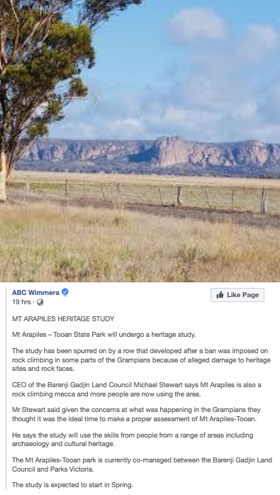
The possibility of Arapiles climbing bans have suddenly lurched forward much faster than expected – with the announcement overnight of a heritage study to start at Arapiles by Spring this year – according to an ABC Wimmera News article. The article references the “alleged damage to heritage sites and rock faces” in the Grampians as the reason for urgency.
Summer Day Cultural Assessment Begins
The official assessment of Summer Day Valley & Hollow Mtn area by the Victorian government dept Aboriginal Victoria (AV) has actually already begun this week. This is most likely prompted by the looming expiry of Licensed Tour Operator permits to the area that end in July. There has been no official release of information about this assessment (and probably never will be) but there has been rumors of new Aboriginal sites found and some unease with the track works and infrastructure already built by PV. We remain hopeful that the climbing zones within Hollow Mountain SPA area will be given the green light by AV but everyone probably needs to cool their aspirations in the short term whilst the details are sorted.
Despite saying otherwise in the Halls Gap LTO meeting a few weeks ago, PV CCO Simon Talbot has clarified that the $1.2 million quote for cultural heritage assessments is the amount it would cost to do full cultural and environmental assessments of all of the SPAs in the Grampians – not just Summer Day Valley. Talbot has indicated that the cost of this will be able to be minimised as they will focus the assessments on where there is actual activity occurring. But what about the costs of assessment of other crags not in SPA areas that are already being mentioned? (Bundaleer, Taipan, Black Ians, Arapiles)
This cultural heritage assessment of SDV will be an interesting test case for the Grampians bans. Many have asked what is the exclusion zone radius being applied to cultural heritage sites. We all know that there is a whopping big tourist track, toilet block and car-park within a hundred metres of Summer Day Valley. Right now we have a legally questionable SPA ban over the whole area (SDV to Hollow Mtn Cave and beyond), plus an earlier poorly communicated ban from 2011 on SDV’s Main Wall. The latter was only enforced with sign consisting of a piece of laminated A4 paper nailed to a stick (which fell down years ago). Climber’s do not want to interfere with cultural heritage sites – but we also need to know clearly where they are and how far to keep away from them. Having a huge circle around a large area (SPA) surely devalues the actual importance of specific sites? That it took 8 years for this cultural heritage assessment to happen at Hollow Mountain, after the unearthing of a new site at Main Wall in 2011’s flood, is truly bizarre. Especially considering the high use and PV approval of this area for commercial guiding and school education in the years after.
Summer Day & PV’s Education Agenda
To get an idea of just how ingrained Summer Day Valley was to Park Victoria’s education agenda earlier this year (and years past) you only have to read their Grampians Excursion PDF, which is oddly still available on their website (but we’ll put our own copy online as they have deleted things like this in the past when we point them out). This document is a guide for teachers and students who plan to visit the Grampians National Park and gives them ideas for excursions at various locations around the park. What features on the front cover? Rock climbing! At now banned Summer Day Valley no less.
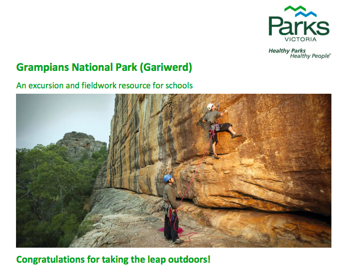
In PV’s own words “Summerday Valley provides an opportunity for introductory rock climbing lessons and a study of recreation
and park management strategies.” We couldn’t agree more. Despite recent dramas, SDV is a great example of previous mutual co-operation between the government, Aboriginal and climber interest groups. In the document PV uses Summer Day Valley as an example case study of good park management for visiting students. Have a read:
Case Study: Managing a dynamic natural landscape at Summerday Valley
Summerday Valley is a site within the northern Grampians that has been largely influence by natural disaster and human use of the site. After a major fire in 1980s, severely burnt vegetation meant Summerday Valley unintentionally opened up as a popular rock climbing site. Many access tracks criss-crossed the area, causing erosion and loss of stabilising groundcover.
More recently Summerday Valley was affected by flooding rains in 2011-12. Around 280mm of rain fell in just three days creating landslips, overflowing creeks and a massive amount of mud. The flood caused new areas to be exposed, including an Aboriginal cultural heritage site on one of the main walls at Summerday Valley. Three years after the floods, fire burnt the area again and the site was closed for public safety and repair.
The flood and subsequent fire gave Parks Victoria a chance to reassess the site and strategically plan how visitors interact with the natural features while also improving conservation outcomes.
Under the guidance from the park management plan and the Fire Recovery Plan, Parks Victoria, along with financial support from the Grampians Walking Track Support Group, Horsham Rural City Council and CliffCare have redesigned the site to make it more sustainable to visitor use over time.
The sandy, eroded main entry track was redirected to a track over rocks that can sustain more foot traffic. Wire boardwalks are used in wet or sandy areas to minimise erosion and stabilise soft soils. The track now flows better and good planning has minimised soil movement and erosion. Water now runs through the site without causing major erosion. In 2016 the Grampians was subject to flooding rains closing large areas of the park. Summerday Valley remained open and shows the redesigned track work successfully mitigated potential damage.
Within the main rock climbing area, the centre of the site has been fenced off. This area is where the original1980’s tracks cross-crossed vegetation. Visitors and climbers are now redirected around the base, close to the cliff face. Revegetation and undisturbed regrowth within fenced centre area has resulted in rare plants like large leaf ray flower reappearing after being absent for years.
Excerpt from PV’s Grampians-Excursion.pdf
Parks Victoria would probably prefer this history wasn’t discussed considering they now seem to be holding a hard line approach to climbing bans in the area surrounding SDV. Two weeks ago they held a public meeting in Halls Gap with Licensed Tour Operators but still refused to announce the reversal of bans to this area. There is now less than two weeks until their permits expire and all these students have to go elsewhere.
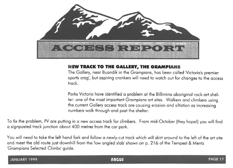
The Gallery – How Did This Happen?
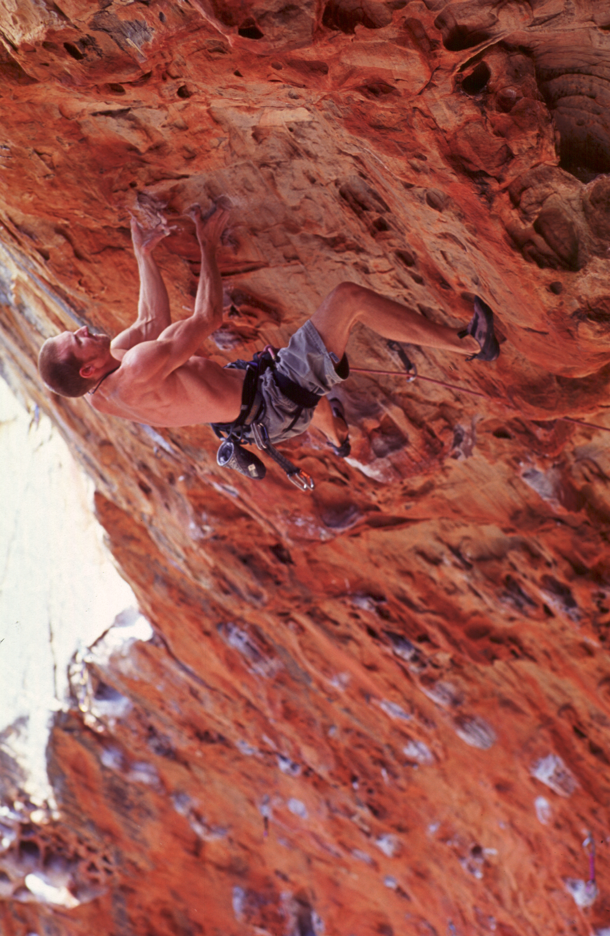
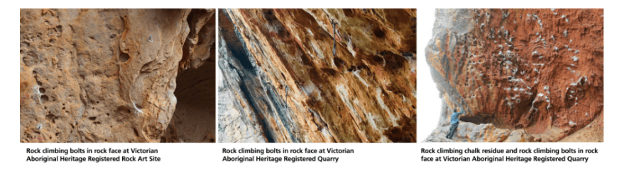
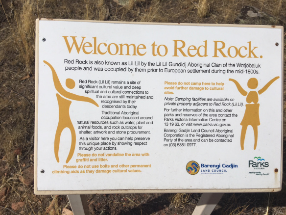
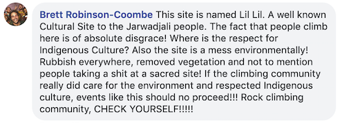
The Gallery is certainly the most visible example of climbers impacts in the Grampians – not helped by the contrasting white chalk against dark orange rock and the use of safety bolts and draws left behind on projects. It can probably lay claim to the high (low?) water mark of climbing development where the interests of climbers overshot the value of the natural area. This area has been the first experience of rock-climbing that several Traditional Owner groups have seen. Some of these groups now believe that all rock-climbing looks like The Gallery. What these groups may not have noticed are the other climbing areas they walked right past on their way up to The Gallery that show little, if any signs of climbing contact.
Many wonder how climbing was allowed at The Gallery for so many years despite it being a registered Aboriginal quarry. There were so many opportunities for someone to step in and let climbers know it was a problem. It is worth talking about intent at this point. Climbers at no stage ever intended to damage a cultural heritage site. Any harm was entirely by accident due to ignorance of the site having any cultural heritage value. We actually don’t know if any harm was done to the quarry itself.
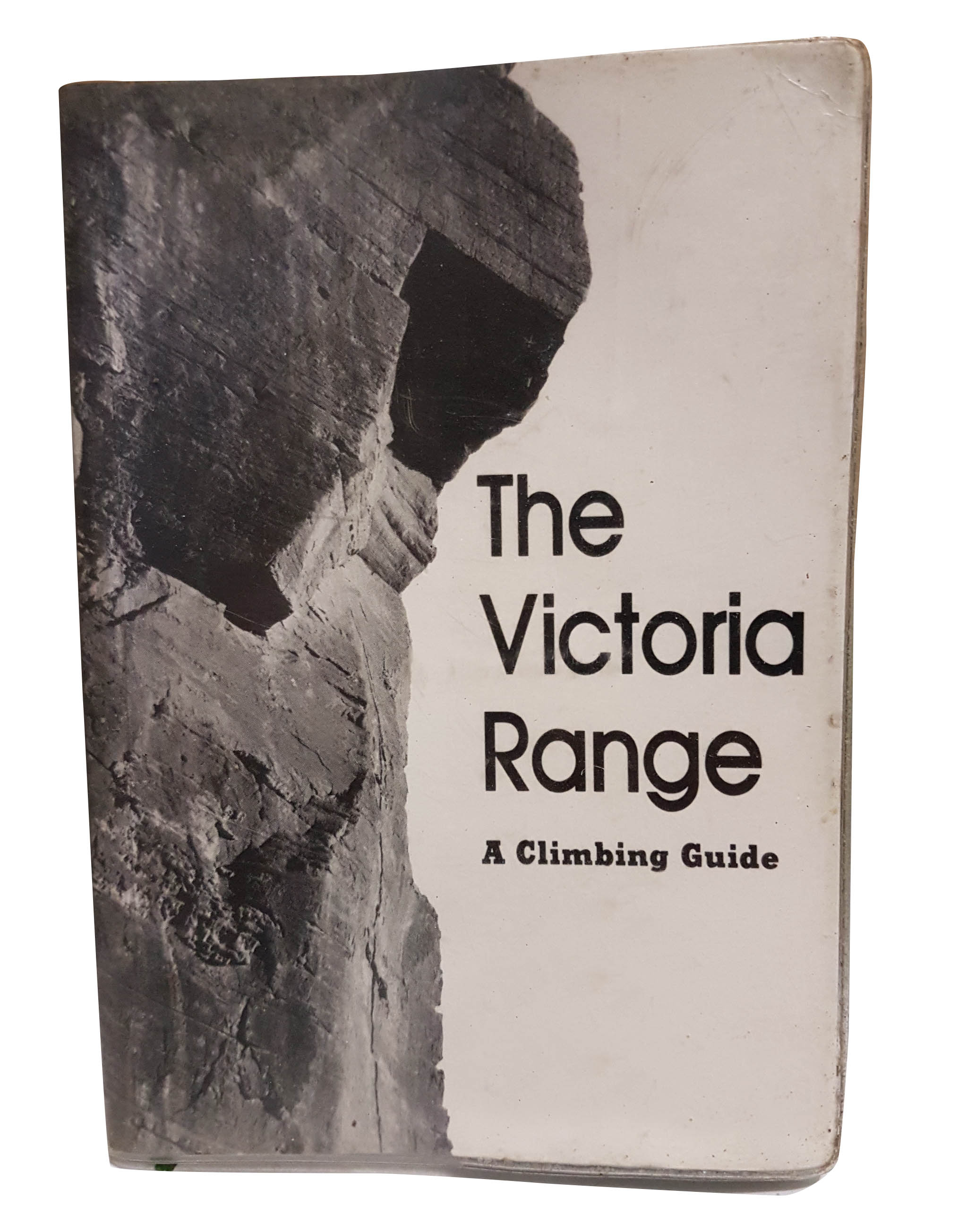
Winding back the clock – the first rock-climbs were established on the summit of Buandik hill in the 1980s and were mentioned in the print guidebook to the area The Victoria Range – A Climbing Guide (1989). These were low impact traditional climbs at low grades.
In 1990 the “Gallery” cave was discovered by new-wave climbers who equipped the majority of routes using fixed slings tied through the pockets and some safety bolts. The name “gallery” comes from the amazing view from the cave – and has nothing to do with art in the cave (which there is none). The area was declared a major find for Australian rock-climbing and was instantly popular. Climbers in this era walked 40 minutes past the caged Billimina art site on their way up the hill to the cave. Anecdotes from 90s climbers say that National Parks removed a 1930s era cage around this art site and replaced it with a new one around this time, leaving old bolts still in the art site itself (the basis of the infamous bolts in art photos falsely attributed to climbers). The climbers walked straight past this Nat Parks work site and no mention was made by rangers working on this site that climbing was not compatible with the area.
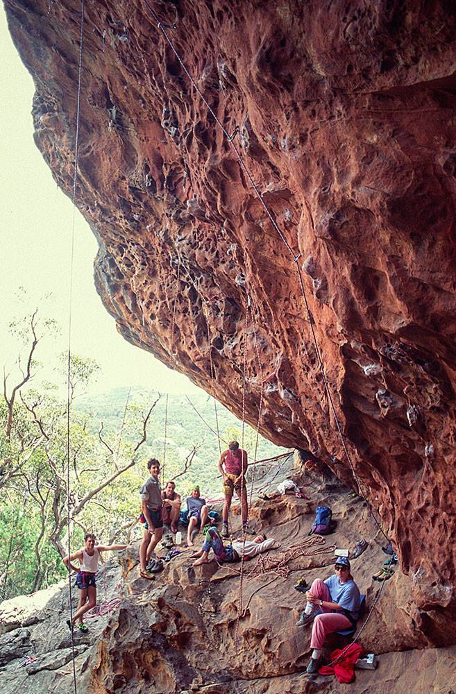
In the mid 1990s The Gallery featured in at least three print guidebooks (available internationally) and photos of it made the front cover of major magazines. By this stage it was now one of the most famous climbing areas in Australia – especially after the route Nicotine was established (one of the first grade 32s in Australia). It was sold to the masses as an “outdoor gym” that offered rain protection and shade. There is no way that PV didn’t know about it – but still there was no mention of it being a cultural heritage site.
In the early 2000s PV became concerned that the majority of foot traffic from Buandik campground was going to the Gallery climbing site via a direct track above the Billimina art site and it was causing erosion. So, putting their land management hat’s on, PV created two separate walking tracks – one that went to the Gallery (that zig zagged up a gentler section of the hill), and a second track that went direct to the art site for tourists. This track work was collaboratively done with the VCC. Again, no mention of The Gallery being a problem.
Buandik campground got a major facelift in the mid 2000s with a new fences and signage installed. The campground was now becoming crowded with climbers and walkers on weekends. The new signs did not mention any problems with The Gallery climbing area which remained super popular and the main reason for visitors to Buandik campground. Chain of Fools, a steep 23, became the second most popular route in all of the Grampians. By 2010 there was now at least two further print guidebooks featuring the Gallery. Still nothing said by PV or anyone else.
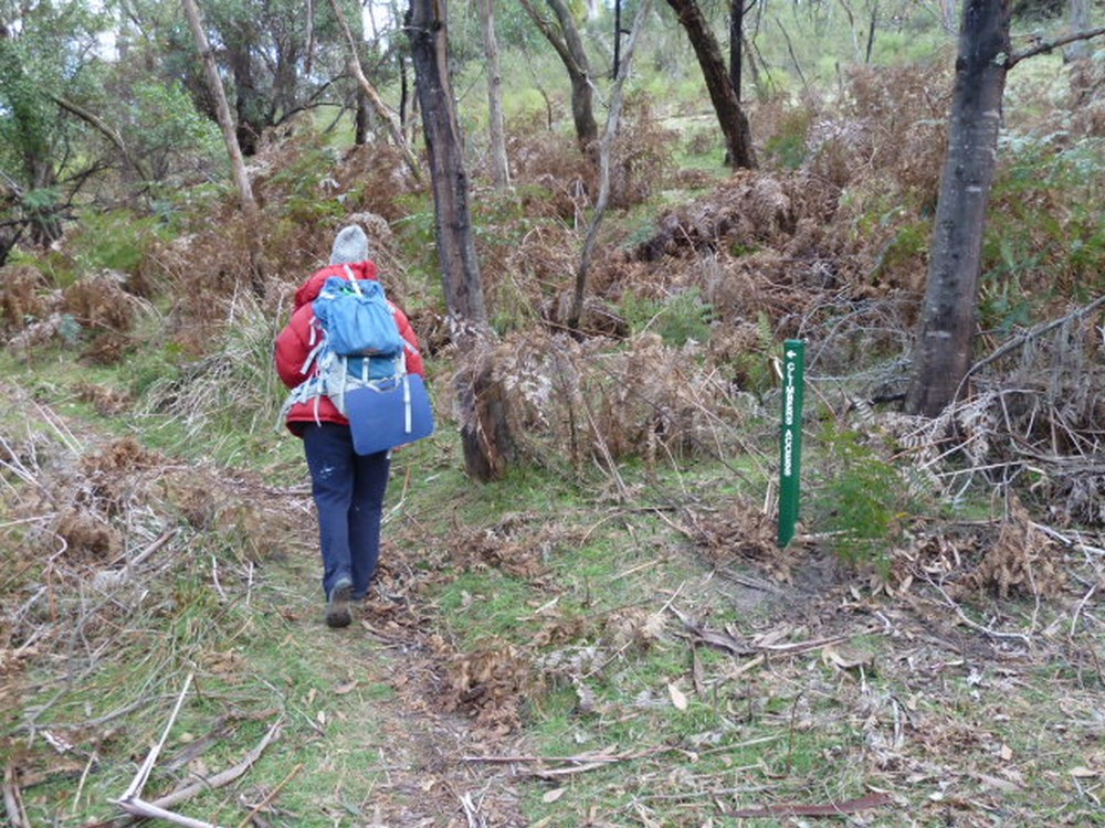
In 2011 floods damaged the walking track to The Gallery (built a decade prior by PV). A working bee was organised in June 2012 by VCC CliffCare and PV’s head ranger Dave Roberts to reroute and rebuild this access track. With the assistance of “Kyle, the walking tracks ranger at PV” a new track was established and climbing specific signage was installed pointing the way to the Gallery. You can read all about this effort on Chockstone or CliffCare’s page. Lots of photos as well. The Gallery was well and truly an approved climbing site.
In February 2013 a major bush-fire struck a fatal blow to most of the environment in the Victoria Ranges, including the area around The Gallery. All climbing in the area was banned whilst vegetation re-established itself and significant PV burnt infrastructure was rebuilt. Climbers followed the ban and kept away for almost a year until the entire area was re-opened officially by Parks Victoria in early 2014. In October 2016 PV published a list of open climbing areas in The Grampians (after the Northern Grampians fires) via a PDF document. The Gallery was on that list. Another opportunity lost to inform climbers about the significant cultural heritage value of The Gallery.
The first time climbers become aware there could be problems was when rangers turned up at the cave in 2017/2018 and started photographing the cliff. But again, these rangers didn’t tell the climbers they were climbing in a problematic area. The climbers continued to climb whilst the rangers looked on. Surely this was the perfect opportunity to let the climbers know something was amiss? Apparently not.
As recently at February this year, Visit Victoria, the governments own tourist website promoted the Gallery as a tourist destination for rock-climbing: In their own words: “Don’t stop on account of the weather. Local caves and shelters provide great opportunities for climbing on rainy days. Popular spots include the Gallery, Millennium Caves and Muline Cave in the Victoria Range” This text was only removed after climbers got in contact with Visit Victoria to let them know the areas were now closed. Surely someone in PV wrote or at least approved that text?
It should now be apparent that The Gallery wasn’t a secret climbing destination. It was internationally famous for decades. What was secret was it’s inclusion at some stage in the Aboriginal Heritage Register as a quarry site. There were so many opportunities to let climbers know that climbing here was a problem but they never materialized. Despite claims by some, climbers were not deliberately damaging a known Aboriginal heritage site. There was no spite or disrespect. This wasn’t vandalism or graffiti targeted at a cultural heritage site. We apologise for the damage and harm done from ignorance. A clean up of this area is well overdue.
Black Ian’s Problems
How is this playing out for climbers elsewhere? It’s not good. Last week the VCC listed an ill-fated club trip to Lil Lil (Black Ians Rocks), an area supposedly still open to climbing despite a bolting controversy 4 years ago. This was the incident where a bolt was placed aprox 3m away from a hand-print and it sparked considerable alarm with Traditional Owners at the time. Many believe this incident is what sparked these widespread climbing bans in the Grampians. Whilst that is not entirely true, it was certainly an agent for change. You can read more about this incident here.
So what happened with that proposed climbing trip to Lil Lil advertised by the VCC? This happened.
It appears that climbers could now also be unwelcome at this entire crag. Brett Robinson-Coombe is apparently an ex-employee of Parks Victoria and left the organisation earlier his year in controversial circumstances. He now claims PV have a conflict of interest because they employ climbers. He was actually the ranger that late last year kicked international climbers out of Muline and handed early draft SPA ban pamphlets. He was the infamous ranger that inadvertently alerted climbers to the PV plan to ban climbing across 33% of the park without consultation.
Again, the proximity of cultural heritage sites to climbing areas is at the forefront of problems at Lil Lil. In the past, climbers have believed that just staying a few meters away was an acceptable standard and this was what was written in guidebooks. Harm was not intended. Climbers believed they were being respectful of the site.
Some other areas have also been singled out recently as being places where climbers are not welcome. The note below was left on a climbers windscreen at Bundaleer. This is not an SPA area on the official prohibited list. In fact, its one of the only remaining “famous” climbing areas of the Grampians that remains open. Attempts to get clarification on the status of both Lil Lil and Bundaleer as climbing areas from PV have not been successful. Radio silence as usual.
Social media can sometimes be quite venomous but this week there have been some early thawing of relations between climbers and the Aboriginal community. It is clear the Aboriginal communities main fear is future damage to other sites in the park. With a climbing management plan being drawn up, cultural heritage assessments taking place, a new route moratorium in effect and widespread knowledge about cultural heritage issues now present in the climbing community we hope these fears can be allayed.
Vertical Life published a good article today about the economic and social costs of the Grampians bans, and the future effect it would have if the same thing happened at Arapiles. Read it here.
As always please share to help spread the word.
