Victorian National Park Association are claiming that climbers have created 1000km of un-offical tracks in the Grampians. We believe the figure is closer to 15km. Let’s dive in!
The Victorian National Park Association is an organization that should be somewhat allied with rock climbing. It is generally anti-commercial development and pro-environment. Encouragingly their website actually has a picture of Arapiles when you click on the “about” button.

So it was disturbing to read a call to action news article on their website that had some wild claims:
“Visitation is increasing and there are now thousands of rock-climbing and bouldering sites through the park, creating possibly 1,000 km of informal, unplanned access tracks throughout the Grampians and the Black Range.”
And on page 26 in an article in their September newsletter they continued with the same theme.
“rock climbing in the Grampians is well out of control with thousands of climb sites, and maybe 800–1200 kilometres of informally created tracks webbed across the park”

There has been similar claims made on Parks Victoria’s website including:
“Some rock climbing practices can have a negative impact… as a result of the development of informal walking tracks, cutting scars throughout the wilderness, to gain access to hidden crags. This involves everything from incidental breakage of small tree branches to more intentional destruction such as using chainsaws.”
We feel this is factually incorrect in a large way and greatly hindering the way climbers are being treated. Where did VNPA get these outlandish figures? This article is an attempt to refute the claim that climbers are somehow responsible for “800–1200 kilometres of informally created tracks webbed across the park”. Hopefully this can clear up some serious misconceptions among the general community (and Parks Victoria) about climbers tracks.
We believe, using research and our expert knowledge of the Grampians, that informal climbers tracks would be less than 5% of their stated claim, 50km at most, and less than 15km would be used weekly. We calculated the distances of tracks to crags where there is a discernible climbers track – we did not include faint foot pads requiring bush navigation experience (the majority of climbing areas). You can view the spreadsheet of the distances here:
Climbers use tourist tracks most of the time
Climbers are blessed with an already established network of old logging roads and PV created walking trails that they use to access the majority of the climbing. For example, in the most popular areas for rock climbers in the Grampians (Stapylton, Hollow Mtn and Summer Day Valley) climbers share the same tourist tracks that hundreds of walkers use for the majority of their approach. Only the last 5 minutes of their approach is “off track”, with many of these informal climber trails actually being scrambles or rockhops on natural stone where erosion is not a problem. In the entire Northern Grampians area there is roughly 4km of climber trails – many of which are on rock rather than dirt. Elsewhere in the Grampians “off track” trails are supplemental to long sections of fire or waterworks roads. For example in the Victoria Range climbers walking to Eureka Wall follow 2km of dirt road, before hiking only 500m “off track” to the cliff. This is considered one of the longest approaches in the Grampians.
Climbers don’t manufacture tracks
Most climbers tracks are tiny and insignificant – in most cases little more than animal tracks meandering through the bush. Unlike a PV sanctioned and manufactured official hiking trail, climbers tracks are just paths that have been formed by the passage of feet. Most begin as a feral goat track or natural weakness through the bush (a ridge, gully etc) and develop over the passage of time and flux with the popularity of an area. Climbers don’t construct these tracks using tools or machines. There are no bulldozers, chainsaws, pickaxes or handrails. Some vague tracks may be marked with rock cairns to aid navigation and reduce track braiding. When a bush-fire occurs these minor climbers trails disappear completely. This happened all over the Grampians a few years ago after the major fires in the Victoria Range and Northern Grampians.
Climbers don’t walk for more than an hour
Because climbers are carrying heavy equipment, usually up hill, the distance climbers are willing to walk to go climbing is usually restricted to short lengths when compared to bushwalkers or mountain bike riders. The average walk-in period for a climbing crag in the Grampians is around 20-30 minutes. This equates to around 1km. How did we come across that figure? Flat walking pace is about 5km/h on paved roads – climbing approaches are steeper and rockier so the pace is much slower. Half an hour at 3km/h equals around a 1.5km approach. The absolute worst case climbing approaches in the Grampians would be no longer than 90 minutes – and this is usually because the approach is not on any sort of track, just pure bush walking navigating by compass and Google Maps. Again the distances are short because the terrain is hard going. Climbers simply do not go into the deep heart of the Grampians. A 5km approach would be considered epic. Now compare that 1km average distance to what the casual bushwalker is doing in a day – 15-20km is a good day in the outdoors. So one bushwalker is equivalent to 15 climbers impact on the trails. Do they really want to play this comparison game?
Not every crag has a track to it
Just because a climbing area is listed on the website thecrag.com does not mean there is any sort of track to it. The majority of climbing areas in the Grampians are rarely visited – some may not have been visited for many years. There was a period of great exploration in the 70s and 80s where most bits of rock in the Grampians were investigated by rock climbers and catalogued for their climbing merits. Old guidebooks from the era are full of routes that have probably had a handful of ascents and then forgotten in the 21 Century. This golden age of climbing was a period of ground up trad first ascents with very little impact. There may be many hundreds of crags listed online for the Grampians but there is not 100s of tracks. There is no more than 30 climbing crags that are visited regularly – and the majority of these are accessed via PV built tracks.
Tracks don’t equal crowds
Unlike a tourist track, a climbers track isn’t being hammered by hundreds of users a day. Even at popular areas most of them would get minimal, if any, use during the week and see 5-10 people on a weekend. This is not bulk tourism.
Climbers can do better
There are things climbers can do better – don’t build rock cairns (bush rock is habitat for animals) and avoid loose soil that easily erodes, especially after bushfires or floods. Stick to one path – don’t make many in one small area. Walk on rocks in preference to soil and vegetation. There are only a few climbing crags that have warranted track work to stop erosion – and CliffCare has done a wonderful job in the past (collaboratively with PV) to help solve this problem. Summer Day Valley, Bundaleer, Taipan Wall and the Gallery have all had minor stabilization work done on their approach tracks (no Grampians Peaks Trail style bridges, metal walkways or handrails!). There are a couple of crags which could do with a bit of work. Watchtower is the main one – it has copped an absolute hammering from Licensed Tour Operators in recent years and is heavily eroded.
Official isn’t always the best
So there you have it – climbers regularly use around 15km of un-official tracks spread across 1,672 km². At most, these tracks only stray a few kilometers from carparks and are used by a handful of people daily. Now compare this to what PV is building right now, the Grampians Peaks Trail, a super highway that stretches for over 160km straight through the middle of the National Park. Their aim is to attract more than 300 people per day on this track. Don’t forget this trail is far from roads and is being cut through the guts of some of the remotest parts of the Grampians. The users of this trail are also using it night and day – and camping along the length of it.
You might also remember that earlier this year Parks Victoria said that climbing was prohibited in SPAs but “bushwalking and picnics” were allowed. Interestingly this seems to have been removed from their website in recent months. Effectively Parks Victoria is now saying that any person walking “off track” – away from an engineered tourist trail is doing wrong. What a ridiculous state of affairs for a piece of public land. Overuse causing environmental damage is indeed a potential problem that we all need to work to avoid. But let’s not let PV introduce draconian bans on exploration and adventure because someone made up some ridiculous and poorly researched figures.
Please share!

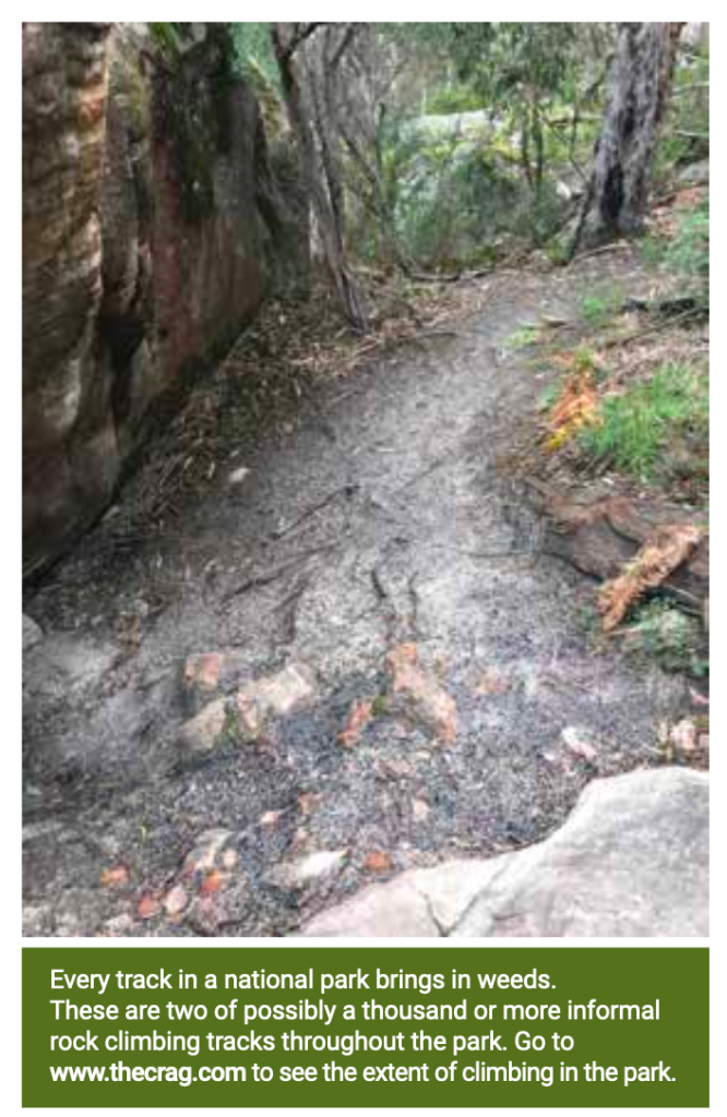
The Picture above… does anyone know where this is? I can’t remember seeing any climbers track that looks like this. I most closely resembles the tourist track up to Venus Baths (that climbers also frequent).
LikeLike
I know this will never happen, but this is a good example of why Grampians section of the Crag should just be shut off. Having all that information out there (just like with all social media) was great when used for the right purposes, but people should have twigged years ago that it would be misused for nefarious purposes and also misunderstood. They should have stuck to guidebooks, hand drawn maps and text description – if you can’t find somewhere in the bush without google maps you shouldn’t be there.
The utopian dream of free and open communication of information was doomed for failure eg the social credit score. The savvy surfers of the old days understood this well and kept things to themselves. Long live The Search.
LikeLike
PS I was once accused by a PV ranger of creating tracks to a crag, I was told the tracks were obviously created using tools such as shovels….. These “tracks” in fact were extremely obviously kangaroo tracks. No human impact whatsoever. Might see a dozen people per year. Obvious as in the many tail and foot/claw prints …. and then the dozens of actual kangaroos you bump into of an evening walking out. I was flabbergastered at this coming from an actual ranger on site.
Not making this up…. Sad!
LikeLike
Do you think that eventually these areas will be completely closed and only tour operators will have access?
LikeLike
We think the Summer Day Valley restrictions (guided tour groups only) is likely to appeal to PV. More and more roads are also being gated to restrict access as well.
LikeLike