
Want to see climbing at Arapiles continue in the long term? Aboriginal Victoria is proposing a proper ban, with large fines attached, on Dec Crag and they want your input into the process. This article covers some of the details on why we need your submission.
This morning Parks Victoria emailed people who had registered to know more info about Declaration Crag/Taylors Rock with a major update.
Read it here.
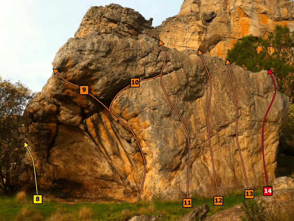
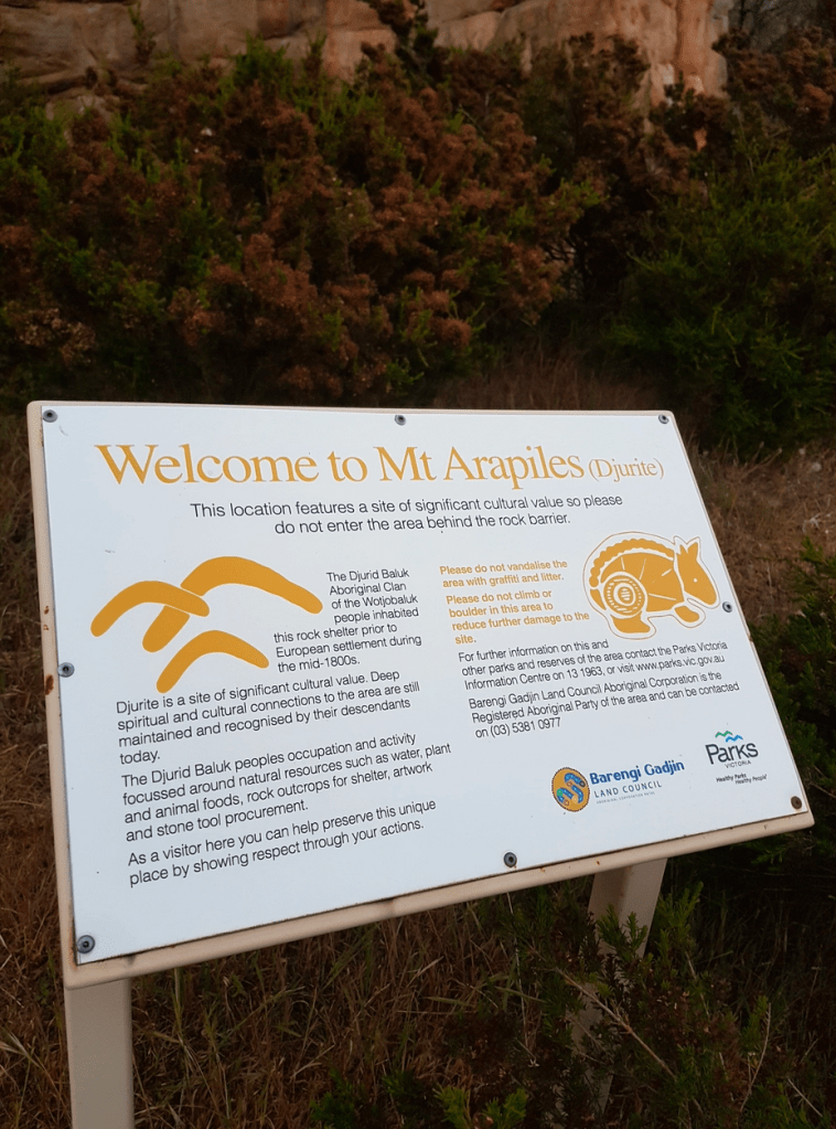
What is this all about? In December last year Parks Victoria announced the rediscovery of cultural heritage at Declaration Crag (known also as Taylor’s Rock). They also requested that no one enter the area effective immediately (a huge surprise to climbers obviously). This is one of the most important areas for commercial guiding due to it’s ridiculously easy access (10 metres from the road) and easy routes. Bouldering is also very popular and of course we can’t forget the classic harder routes including Little Thor (20) and Steps Ahead (29). For some background information on the announcement of the original ban and how it connects to the Grampians please read our previous articles Dec Crag Ban Announced and Is Arapiles Next?
Where is the Cultural Heritage exactly?
We simply do not know – as this is part of the secrecy provisions of the Aboriginal heritage system. It’s on a need to know basis and climbers don’t need to know apparently. We have unconfirmed reports there is art on the Brain Death boulder (the nearest bit of rock to the road at Arapiles) and also on a small charcoal stained cave on the east face of the cliff – right of where many of the easy routes popular with guiding are located. Apparently there is no chalk or bolts physically affecting the art. Is there also items of interest on the south and western sides? We have no intel on that.
Informal “ban” to end, formal to begin
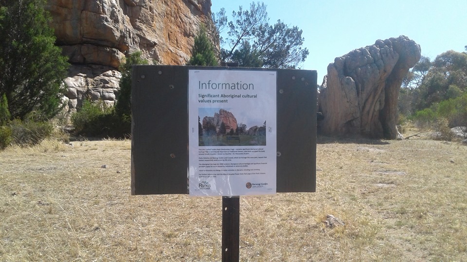
Up to now the “ban” on people entering the entire area has been informal – more a voluntary gentleman’s agreement between the Barengi Gadjin Land Council, Parks Victoria and other park users (predominately climbers). It was not enforceable – no fines applied but everyone was abiding by this arrangement and kept out. There are a couple of signs around the perimeter – but no fences.
According to Aboriginal Victoria this informal agreement is about to end – with an “Interim Protection Declaration” now being proposed (oh the irony of that name). What does that mean? At a basic level the area will be officially off limits to all for a period of 3-months – with heavy fines if breached – maximum penalties for contravention are $297,000 for an individual (?!) ; or $1.65 million penalty units for a corporation. Does this sound like a bit of an overkill?
Let’s look at the actual application document:
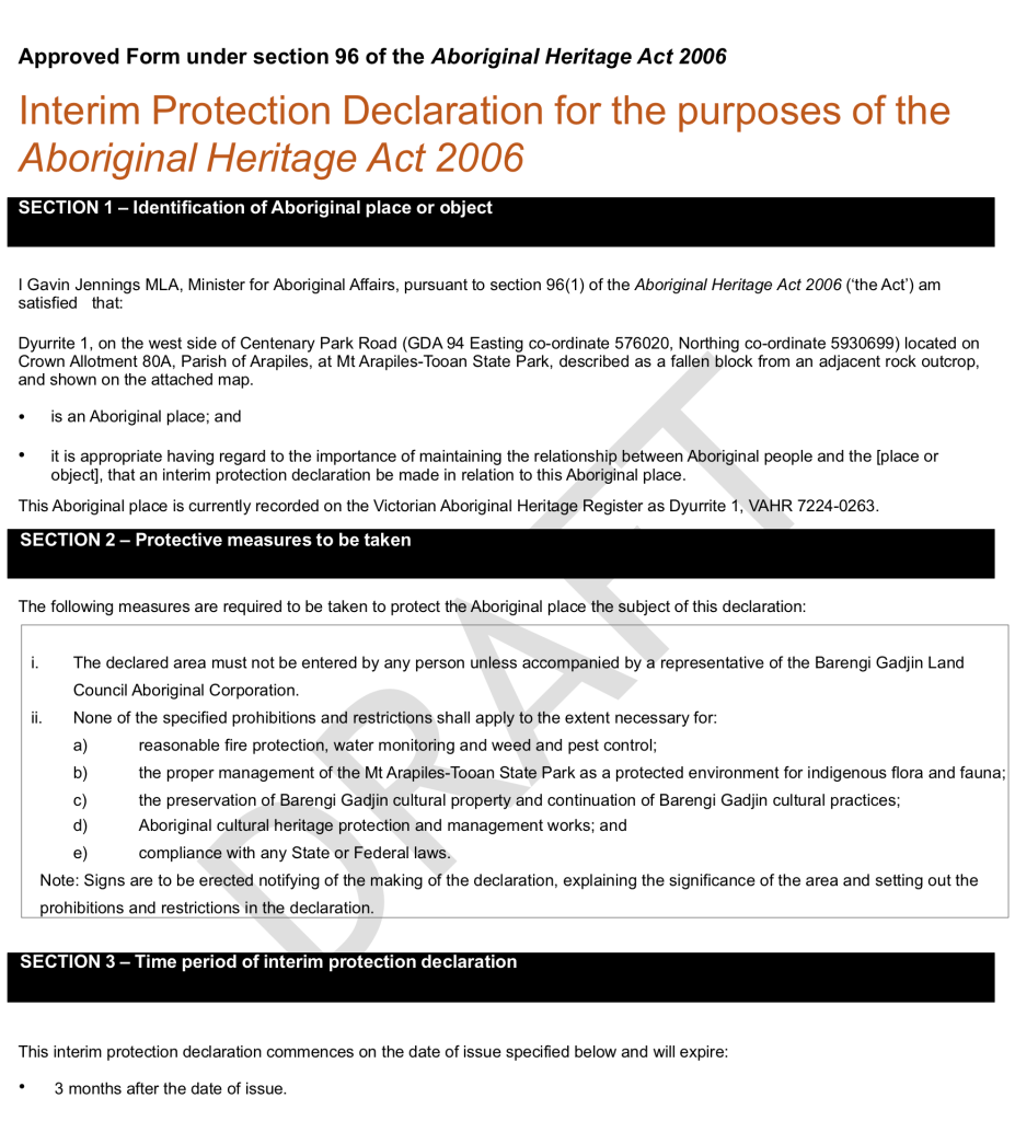
The key point we want to discuss is Section 2 i.
“The declared area must not be entered by any person unless accompanied by a representative of the Barengi Gadjin Land Council Aboriginal Corporation.”
This is not targeting a specific recreational pursuit – but the entire Wimmera community who once used the area. This is a ban on everyone – walkers, picnickers, bird watchers and of course rock climbers. Fencing off a substantial area is something we have not seen anywhere else in the region – even in The Grampians. At that area there has been zoning related issues around Special Protection Areas where the plan of management states that rock climbing is marked as “not appropriate” – but this is legally dubious and possibly impossible to enforce (PV admits this). Even in the most strictly policed areas – the 8 sites where specific legal determinations have been put in place (Gallery, Millennium etc), people are still allowed to walk around the area and have a picnic. This will not be the case at Declaration Crag if this proposed “protection declaration” is approved. You will face a substantial fine even if you walk past the signage “unless accompanied by a representative of the Barengi Gadjin Land Council Aboriginal Corporation“. This is more like an Uluru ban than anything we have seen applied in the Grampians or other Victorian climbing areas.
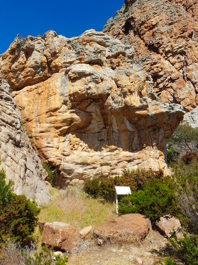
Why do they need such an exclusion zone? All Aboriginal sites are already protected automatically by The Aboriginal Heritage Act 2006 and “significant penalties apply for harm caused by individuals or corporations“. This applies to any art, quarry etc at any climbing area – within a special protection zone or not. You break it you will pay. There is no need to fence off and bar all access. There is already a well looked after (and unfenced) area just right of the Plaque at Arapiles – no exclusion zone there. We see miniature versions of physical exclusions when they build cages over art sites in the Grampians and Black Range. But whole rock formations that have been used for 50+ years as a major recreational area – now totally shut? There is no precedent. Especially when there appears to be no trigger for a dramatic escalation in management (no bolts or chalk suddenly appearing over art etc).
Precedents form the basis of future management directions. We have seen this happen in the Grampians with Summerday Valley pay-per-climb model now being applied to other crags such as Lookout Point Wall. Could this full lockdown of Dec Crag get applied to other Arapiles areas? There is a proposal for a formal archeological survey of all of Arapiles this year, but this has yet to be started as the Grampians, bushfires and now the virus have drained resources. These new finds at Declaration Crag were discovered by accident and were not part of a formal search for art. If an archeological survey finds other areas of Cultural Heritage at Arapiles – will they also be fenced off with total visitor exclusion? People cried alarmist nine months ago when we suggested these sort of exclusions could happen at Arapiles – but here we are staring down exactly as we described today.
It’s temporary – right?
Technically this is labeled as an interim solution. This 3-month ban can be extended by a further 3-months only once – and then would need to be replaced by a more permanent “Ongoing Protection Declaration“. It has already been 4 months since the informal signs went up. Looking at the bright side – this at least will get a proper assessment process actually moving. As a pessimist (or realist) the fact they have asked for this full scale exclusion is a sure sign of the intended end game. It is very rare for restrictions to be wound back once in place – interim or not. All decisions about what happens at Dec Crag are not being made by Parks Victoria or Aboriginal Victoria – but is the responsibility of Barengi Gadjin Land Council.
Numbers don’t add up
How big is this area? Well the original Parks Victoria maps for the “informal” ban released in December showed a large buffer zone around all of Dec Crag – right up to the road – a total of 9064m2.
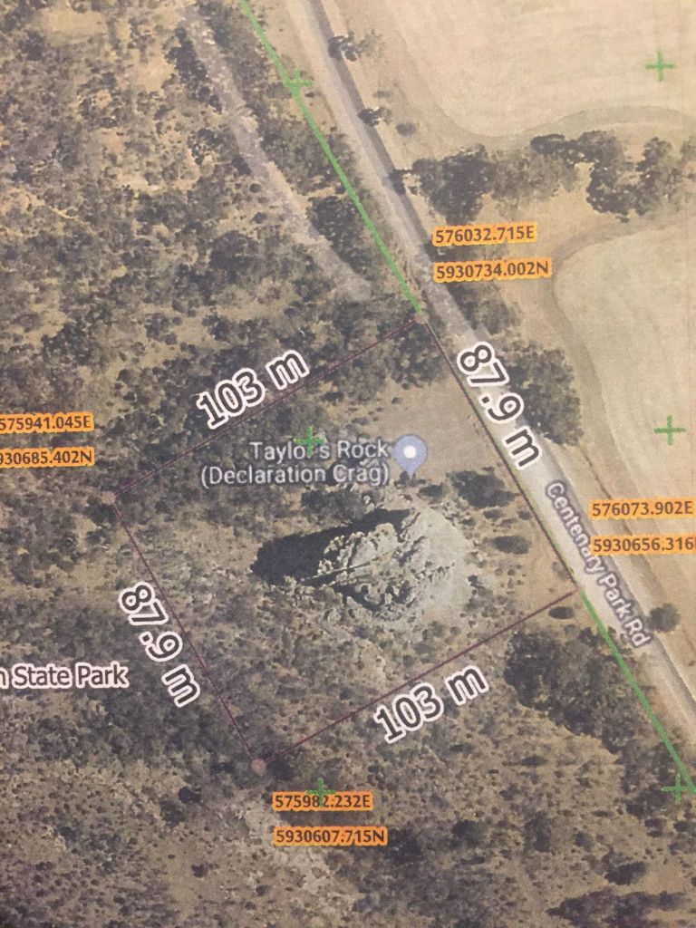
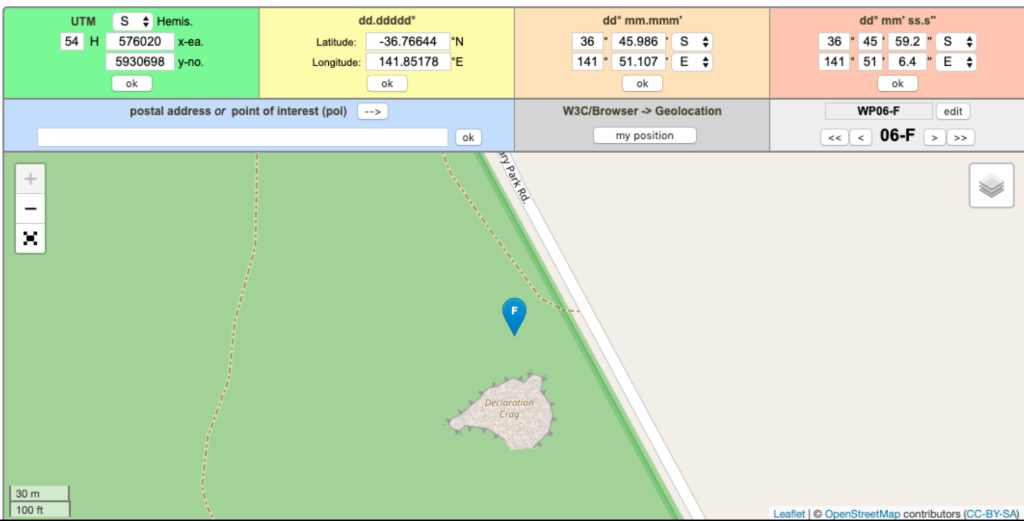
The new formal ban proposal is for a much smaller area. Or is it? In a totally unsurprising twist – there are three quite conflicting bits of information in this proposal about the location and size of the off-limits area. The actual legal document about the proposal only mentions a single spot on a map (GDA 94 Easting 576020, Northing 5930699) which is smack bang on the Brain Death boulder – no radius around this point is mentioned and no overall area size is given. The object to be protected is described as “a fallen block from an adjacent rock outcrop” – that is a good description of a boulder – but not Dec Crag itself.
But over at the Engage Victoria information page they mention an area size of “approximately 300m2” in the text and also publish a vague map showing a circled area that appears to be 250% larger than 300m2. 300m2 is a pretty small area – about half the size of a typical suburban block – and certainly wouldn’t cover the entire of Declaration Crag. How do we know the map differs from 300m2? It has a scale:
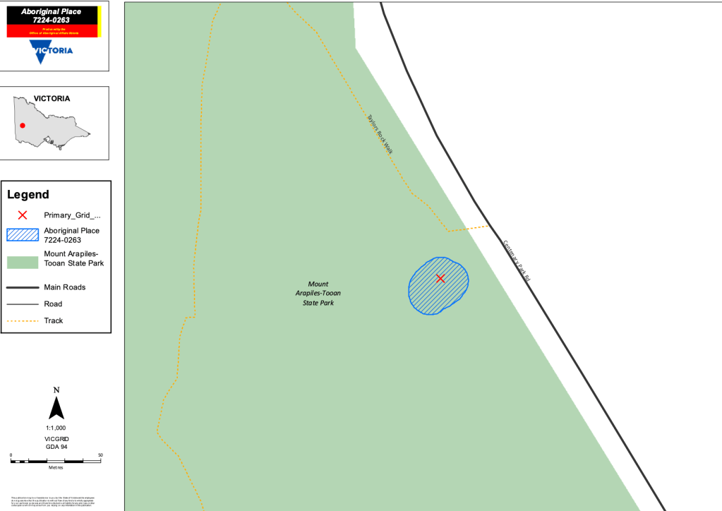
Line that scale up on their blue circled area – do the maths, and low and behold the number appears to be closer to 700m2! That is more than twice the 300m2 that they quote in text. Fishy. But the map is also not very helpful at showing what the circle covers – for that we pulled up Google Maps and did an overlay.
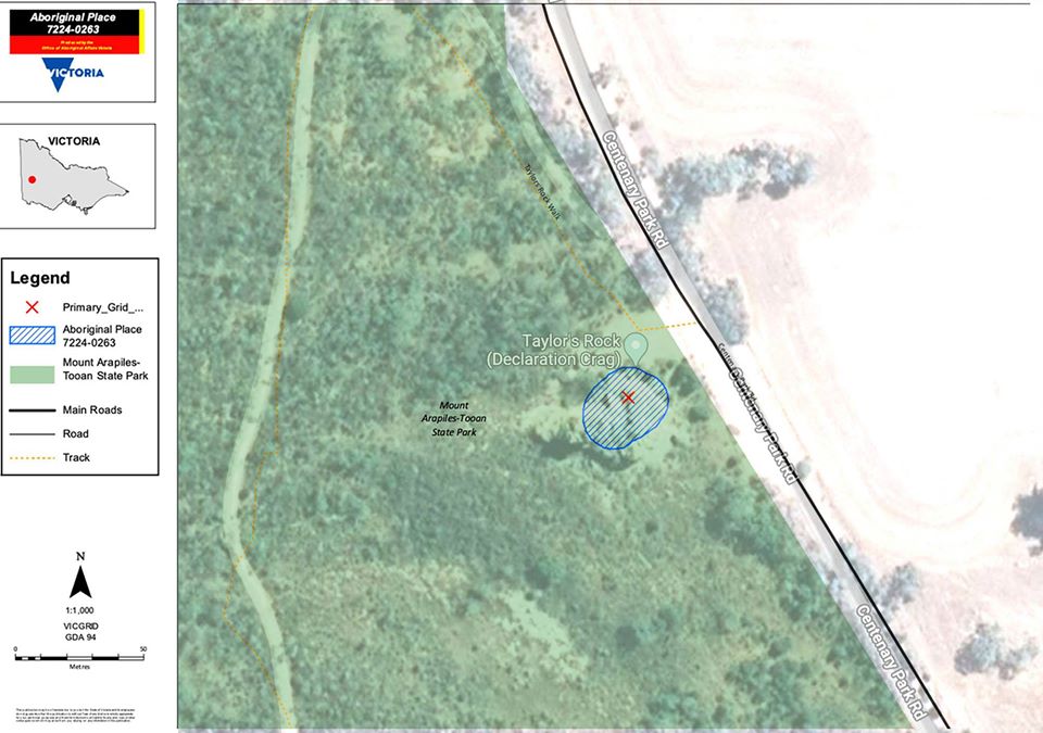
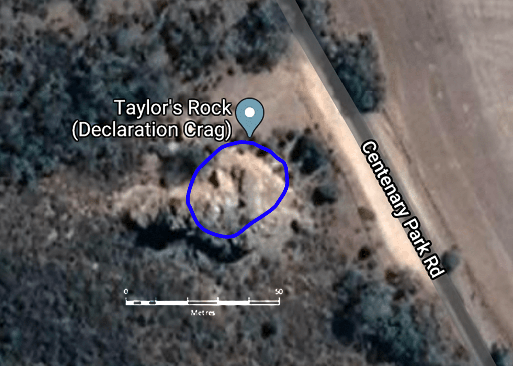
It is pretty clear, according to this overlay, that the majority of Declaration Crag is to be off limits entirely. We would hazard a guess that their maps are a bit crummy and the circle is just supposed to be around the entire lump of rock – which would be substantially larger than even 700m2. Add the boulders on the north side where some of the art is allegedly located and it would need to be even larger. So which is it? Just Brain Death boulder, 300m2, 700m2 or even larger? How are people supposed to comment objectively to this proposal if the information is so vague? Climbers fuss over every square cm of rock. The details matter.
Act Now!
You have until April 22 to make a submission. We strongly encourage you to do so ASAP. There is no time like the present!
Let them know what Declaration Crag means to you (and Arapiles in general). Explain that this is an unprecedented restriction to an area that has been looked after by climbers for many decades. Put your heart into it. But please be respectful to the value of Cultural Heritage – there is so little left – climbers can be part of the solution to protect it and not just a problem. Even if you disagree with everything we have written – send your submission in!
Please send all written submissions to:
Minister for Aboriginal Affairs C/O Aboriginal Victoria
GPO Box 2392
Melbourne Victoria 3001
or
aboriginal.heritage@dpc.vic.gov.au
Submissions must be received by 5 p.m. on 22 April 2020
New Arapiles Advisory Group announced
Parks Victoria has appointed a new Mt Arapiles–Tooan State Park Advisory Group, to serve for the next three years. Eight were selected from 17 applications. New members are Jacqui Norris, Kate Dooley, Mark Gould and Paula Toal. Returning members are Keith Lockwood, Louise Shepherd, Mary French and John Uebergang. This is a very positive outcome – a group with many decades of experience. The group is scheduled to have its first meeting in April.
Please like/share/comment and check out our 50+ other articles at Save Grampians Climbing.
