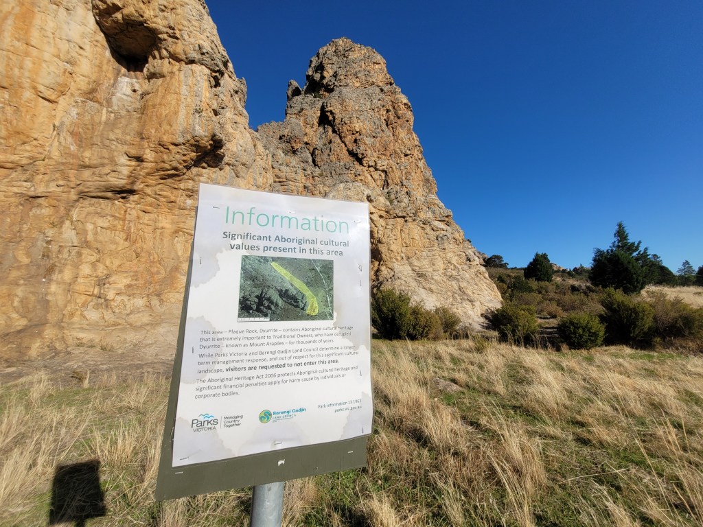
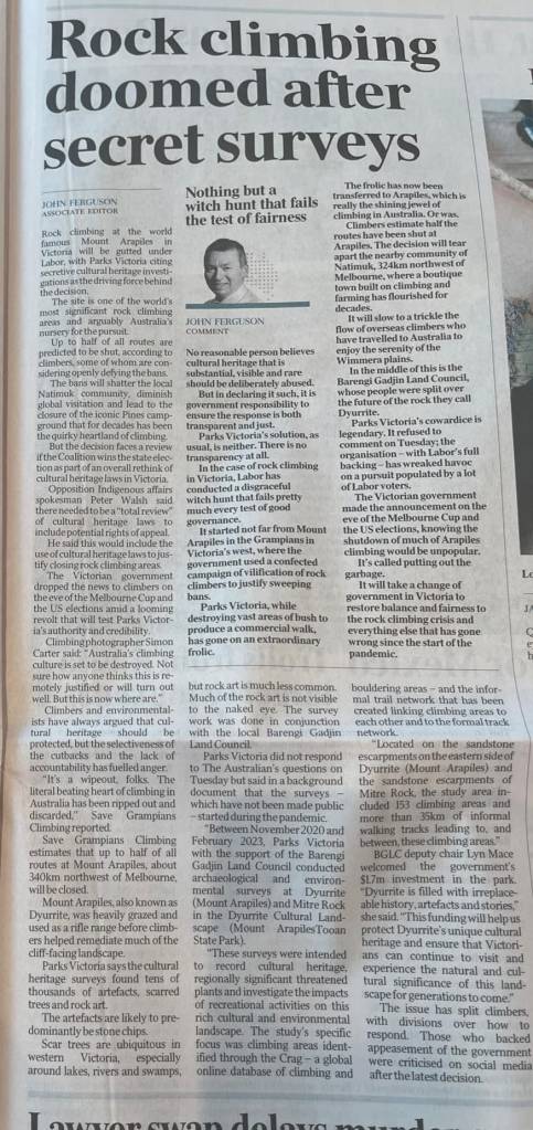
Parks Victoria announces “re-opening” of 18 crags and “more than 500 routes” in the Grampians.
Actual number of routes to be re-opened is 432 – 15% less than PV claim.
The routes being open equate to less than 5% of the total climbing in the Grampians.
Many of the “re-opened” crags are the lowest quality climbing areas in the Grampians – with some having had zero repeats in 40 years according to thecrag.com
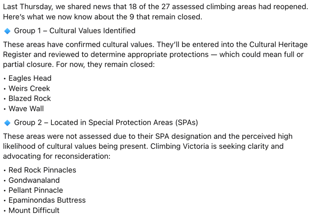
9 crags failed this round of the assessments due to the presence, or potential presence, of Aboriginal cultural heritage.
Major crags failed their assessment without a physical site assessment even happening.
Closed crags include popular moderate sport crags Weirs Creek, Wave Wall and Red Rock Pinnacles.
UPDATE: This article has been majorly updated since first published on Thursday 29 May after additional information was published by PV and Climbing Victoria on Tuesday 3 June.What a surprise – they withheld the negatives of their announcement until after it hit the press.
Have you read the press release from Climbing Victoria and Parks Victoria about an additional 18 areas and “over 500 routes” being re-opened to climbers in the Grampians? Did you look at the list of climbing areas and not recognize most of them? You are not alone!
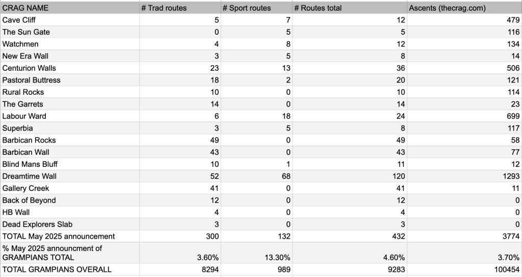
According to the Australian online climbing logbook thecrag.com – the reopened crags contain only 432 routes – not “more than 500” as claimed by Parks Victoria. Even if we only use the figure of 500 routes that is a 15% inflation over the actual figure. What gives?
Mediocre crags in the Grampians “re-opened”
Only an experienced Grampians climber will immediately see why there isn’t great big whoops of joy on what has “re-opened”. The list of areas is far from an inspiring collection of classic crags containing iconic routes. There are around 6 middle of the road good crags listed – Dreamtime, Centurion, Cave Cliff, Barbican and Gallery Creek. The remaining deserve a special mention as they are so bad…
Three of these 18 “reopened” areas have received zero ascents in the last couple of decades according to thecrag.com. Another 7 of these areas have received less than 100 ascents. Five of these “areas” are tiny pimples of rock that contain less than ten routes. Five crags are mediocre at best and are situated in the heart of Halls Gap within walking distance of the Parks Victoria office (they can be back for lunch after spending the morning banning a bunch of crags!). We have it on good advice that PV threw in assessing these Halls Gap crags as a “bonus” for the climbing community – we’re sure they still filled in those timesheets at the end of the day. A couple of re-opened “areas” are simply one piece of cliff line with names for each sectors – they are not even unique climbing areas!
Get psyched for the Labour Ward super crag!
4.6% re-opened
This re-opening announcement has only added a minuscule 4.6% of total Grampians climbs to the already threadbare “open” list. These 18 newly “designated” areas equate to only 3.7% of total climber ascent activity in the Grampians according to the thecrag.com. These re-opened crags are not only small and obscure – they are generally really unpopular.
Sport climbers can rejoice – 13% more open!
Sorry for getting your hopes up. How did sport climbers fare? The majority of the original bans in the Grampians targeted the harder and spectacular caves and walls that made the region famous – such as Muline, Gallery, Taipan, Millennium (RIP) and many others. The best rock and routes on the planet. These “reopened” areas bring around 13% of additional sport routes into play – but if you look at the details you realize most of these are sub grade 20 routes on poor quality grey or blocky rock around Halls Gap – not the magic orange everyone wants to climb. A two bolt grade 10 slab route at the Labor Ward is hardly a replacement for Invisible Fist at Taipan Wall. It’s better than a rock to the head – but not exactly a time to celebrate. Even worse – we have confirmation that some of the best moderate sport crags in the Grampians – Weirs Creek, Wave Wall and Red Rock Pinnacles all “failed” their assessments – more about that later…
Did Parks Victoria and First Peoples State Relations really send a highly paid assessment team on a one hour bush bash up a big hill in deepest darkest Victoria Ranges to assess a cliff such as Dead Explorers Slab – which contains only 3 trad routes (all under grade 13) that have had exactly zero ascents in 20 years? At the same time we have heard zilch about any assessments of world class climbing areas such as Eureka Wall, Muline, Asses Ear and Mt Fox? These assessments continue to baffle logically minded climbers who want certainty on crags that climbers actually visit – and international climbers used to flock to.
The Grampians have over 9200 recorded rock climbing routes and boulder problems – but Parks Victoria still believes they can keep climbers away from 80% of these. An additional 4.6% does nothing to allay the deep concerns that climbers have about the bans and the future of the climbing in Victoria.
Crags that failed assessment
One line from the glowing press-release is worth mentioning “Parks Victoria has assessed 27 climbing areas in the Grampians (Gariwerd) National Park and are reopening 18.” That means that there are 9 areas that were assessed – but didn’t “pass” and are now presumably closed to climbing. What are those areas? According to Climbing Victoria’s Facebook post on Tuesday...
The loss of super pocketed moderates at Weirs Creek and the insanely popular Wave Wall will put even more pressure on the already busy moderate sport crags of I Forget Walls and West Flank. Neither of these newly banned crags are caves so we have no idea what “cultural heritage” value is present and why it took until 2025 to notice it. Both crags are over 20 years old for climbing activity.
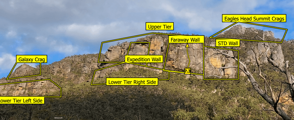
Eagles Head is a big loss as well as it is a massive area – similar to the geography of Arapiles it has multiple tiers, gullies and faces. Banning the entire area seems extreme – but we have seen similar attempts at Arapiles to close major areas due to the the very limited presence of cultural heritage right at the cliff base. Eagles Head has never been popular – but it’s always been a place to “get away” from the mainstream crags and have a proper 1980s style trad adventure. Tights camera action! Historical impact from climbers has always been negligible at Eagles Head. With the loss of so many similar areas at Arapiles this is a crippling blow to the future climbing community.
Eagles Head contains 77 routes over a huge area. The “Summit Crags” represent 3 of the supposedly “reopened” areas, yet no climbers go there. The rest of Eagles Head consists of at least 7 named walls. So does that mean 7 crags banned? PV consider it just one, with 3 opened.
Failure to assess
We note the contradiction in public statements from Climbing Victoria that “Parks Victoria has assessed 27 climbing areas in the Grampians (Gariwerd) National Park and are reopening 18.”
They actually did not assess at least 5 areas of the 27. They just wrote them off on paper without actually checking them out in person.
The failure of Group 2 crags to even be individually assessed because they are simply located in huge Special Protection Areas (SPAs) is of greatest concern to us. These areas were popular and famous climbing areas for over 40 years – and featured in numerous print guidebooks. Now they are deemed so culturally “valuable” that even considering an assessment to continue a long utilized recreational activity is deemed impossible.
A complete ban on Mt Difficult for this reason is laughable – as PV hacked the massive Grampians Peak Trail straight through this area only a few years ago – including massive stone steps carved directly into the cliff. Yet a couple of bolts and a faint foot pad is criminal? Give us a break.
How are the crags being chosen?
Where did the list of areas to be assessed come from and when? It was actually a list of 50 priority areas that was presented to Parks Victoria back in May 2022 by the Victorian climbing community (through the now defunct CVAC – Climbing Victoria Advisory Council). According to this news report Parks Victoria accepted this list “and has agreed to assess them in the 2022/23 financial year. The aim is to complete the assessments and determine which sites will be designated as climbing areas or non-climbing areas by May 2023.” For those viewing this in a parallel universe without the bans – that deadline flew past us 2 years ago. Oops. So two years late and Parks Victoria have only attempted to assess less than half the 50 crags on the priority areas list.
We now have a generation of climbers who simply do not know about what the best Grampians climbing crags are because “assessment” of these areas has dragged on for more than half a decade (and multiple Parks Victoria CEOs). What ever happened about those climber permits? When will the general public be allowed back to Summerday Valley? When will PV put aside real funds to stabilize the bottom of Spurt Wall? Maybe it’s best we just leave PV and their cronies to play with paperwork while we just go climbing.
Thanks should go out to all the organizations and individuals that have lobbied hard to get areas reopened over many years. We have all done it slightly differently in our own unique way but the pressure has been immense and mostly unwavering. Keep it up all. This announcement claws back a tiny fraction of the overall losses but does give some hope that one day this will all be distant memory.
The all important 4th document – the Cultural Heritage survey – remains blocked from the general public’s access.
Documents confirm that climbing historical usage and positive influence on the regional community was not considered into decision making around climbing bans.
Resourcing and budget restraints to “manage” climbing areas will mean climbing bans occur automatically
All public access and use rights at Arapiles should be understood as “temporary” according to documents
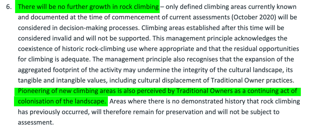
Any new climbing development is labeled as “colonialism” by Traditional Owners and is not acceptable.
All climbing to be banned if “near” tangible and intangible cultural heritage. No definition of “near” is given.
The sounds climbers make are defined as unacceptable to Traditional Owners use of the area and a reason given to ban specific climbing areas. Shhhhh.
No other user group is targeted with such draconian surveys and restrictions.
You have until February 14th to submit a response to Park Victoria’s plan to close more than half of the climbing at Arapiles. Please make sure you send in your submission – your voice counts. We have momentum for change but need the community’s support to get this over the line.
The release of three key documents by Parks Victoria in the last couple of days has shone new light on the “decolonisation” mindset within the organization when it comes to the climbing community’s use of Arapiles.
Decisions decisions – how to ban climbing.
For this article we are going to focus mostly on the 2021 Decision Framework as this document best explains how we got to the situation where Parks Victoria has ended up with a proposal to ban more than 60% of the rock climbing at Arapiles (thousands of climbs) and put the regional Wimmera community of Natimuk into financial jeopardy. At only 10 pages it’s not a particularly long document and worth downloading and reading. We will delve into the flora and environmental surveys in future articles.
The Decision Framework document is labeled mysteriously “sensitive” – presumably because the contents didn’t align with what PV and the Labor Allen government wanted to project to the public (remember the win-win press release they issued – Climbing and cultural wonder of Dyurrite secured – yere that didn’t end well did it?). Why did it take until now for it to be released – 4 years after it was written? It was never shown to Climbing Victoria or other climbing organizations that had regular meetings with Parks Victoria specifically about concerns with upcoming Arapiles climbing bans.
The fact they waited until now to quietly release it shows the government was either embarrassed by its contents (it hasn’t aged well in the political climate) or was deceitful in hiding it knowing full well the implications it would have on the communities response to the proposed plan. With Park Victoria’s CEO and board fired, temporary management and budget cuts the the release of these documents could either be a cry for help from within or a reluctant FOI release after persistent attempts by various members of the climber community to get hold of them. There is only a couple of weeks before submissions close at Engage Victoria. Let’s rip this document to shreds shall we?
Mitre Rock – to be banned in 2025
It’s all about rock-climbing stupid
Although the Decision Framework document is titled with the generic sounding “Dyurrite Cultural Landscape Decision Framework: principles and process” it singles out rock climbing as the problem that needs to be cured. There is no mention of other user groups such as walkers, general tourists, cyclists, high-liners etc who could easily have a similar minor impact on the ecology and cultural heritage of the area.
The objective briefed to the Flora survey also “targeted” rock climbers – with the summary of that document clearing stating…
“The objective of the current assessment was to undertake targeted surveys for threatened plants, focusing on areas used for rock climbing activities. [snip] The conservation and statutory risk to threatened species has been assessed with a focus on potential impacts from rock climbing activities.”
This means that the study only targeted high use climbing and walking areas (except one small area of low use climbing). The Flora report would have more reliable data if a comparison had been made for rare and threatened plants in the acres of rock where climbers do not frequent (“low use” or “no use”).
But regardless, the report itself states: ‘There was no clear pattern between the level of rock-climbing use and the distribution of threatened plants.’
and
“The cause and effect implied is not able to be determined with the few observations made, and the correlation may be coincidental.”
The report is a good snapshot of what is located in climbing areas, but it cannot be used to assess the impacts of any potentially threatening process (including rockclimbing). Your tax paying dollars at work.
Decision makers
Back to the Decision Framework and who is responsible for brewing up trouble…
“Parks Victoria and Barengi Gadjin Land Council are working together to undertake a project in 2020-21 to assess and evaluate defined rock climbing areas in Mount Arapiles-Tooan State Park. The assessment of cultural and natural values within these areas will provide an evidence base to inform decisions regarding future climbing opportunities. This document establishes the framework for how these decisions will be made.” – p.1
That makes it crystal clear BGLC is working directly with Parks Victoria on how to close rock climbing areas. Don’t get distracted by calls that they merely “assessed” the area and someone higher up in State land made the bans. The very methodology on how to ban climbing was cooked by these two organizations in this document without input from the climbing community or anyone in Natimuk or the Horsham LGA. This is how they operate – oversight not required. The document routinely refers to Traditional Owners who we can only assume is BGLC – it is doubtful they asked anyone else as there has been alleged confusion amongst outsiders of BGLC in the local Aboriginal community on these climbing bans. The document clearly states that climbing access will only be allowed at each area with the approval of Traditional Owners (p.4).
Precautionary approach
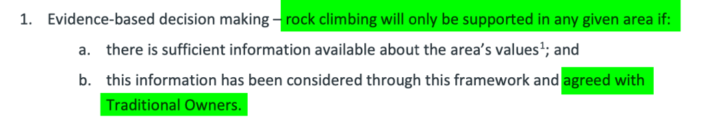
“The future regulation of rock climbing is proposed to be based on an approach of ‘designated climbing areas’. Climbing would be prohibited across the park except within Designated Climbing Areas in accordance with specified conditions. The approach is consistent with the overarching and management principles and provides a precautionary regime based on the evidence of values and risk.” – p.1
More commonly known as ban first, ask questions later. This is the same system they introduced into the Grampians in 2021 and likely to be coming to every climbing area in Victoria soon. Unless Parks Victoria can drum up resources to “assess” and “manage” an area in detail they will ban the public’s access to it. This is the future of National Parks in the State. They fear what they don’t know. It’s also really simplifies their work.
“Under the proposed management approach of designated climbing areas, the setting aside of discrete specific areas to exclude climbing would become redundant. Instead, climbing would be prohibited broadly across the park via set-aside determinations, except within a designated climbing area and in accordance with specified conditions.” – p.9
This entire area, once a popular area for outdoor education, has been shut as a “precaution” since 2020.
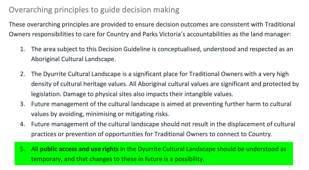
All public access and use rights should be understood as “temporary”
It says it right there on page 4. No one should be under any illusion otherwise. This is what the “land managers” tell us. Public access to public land is being eroded – with the very existence of “public” land changing to ownership by Corporations with their own internal agendas. Read our previous article here about that.
Tangible or Intangible – it’s all banned automatically
On page 5 we get some solid information on what triggers a climbing area ban because of Aboriginal cultural heritage. There is a bit to unpack here.
Now this appears to quash all hope on climbing being allowed near stone tool manufacturing sites – we covered this dilemma in detail in our article “We Need to Talk about Quarrying“. But there is some hope – as the definition of “near” is not made in the document. If it was defined as one or two metres then that would open up the majority of climbing at Arapiles. But if they want to put wider exclusion zones in excess of ten metres they would shelve the majority of rock climbing in the park – which appears to be what they have done. Does this same exclusion apply to potential cultural “tourists” – it would be hard for any tourist to appreciate a chipped rock edge or extremely faded rock art if they are being told to stay 10m away? Double standards of course apply – standard PV policy.
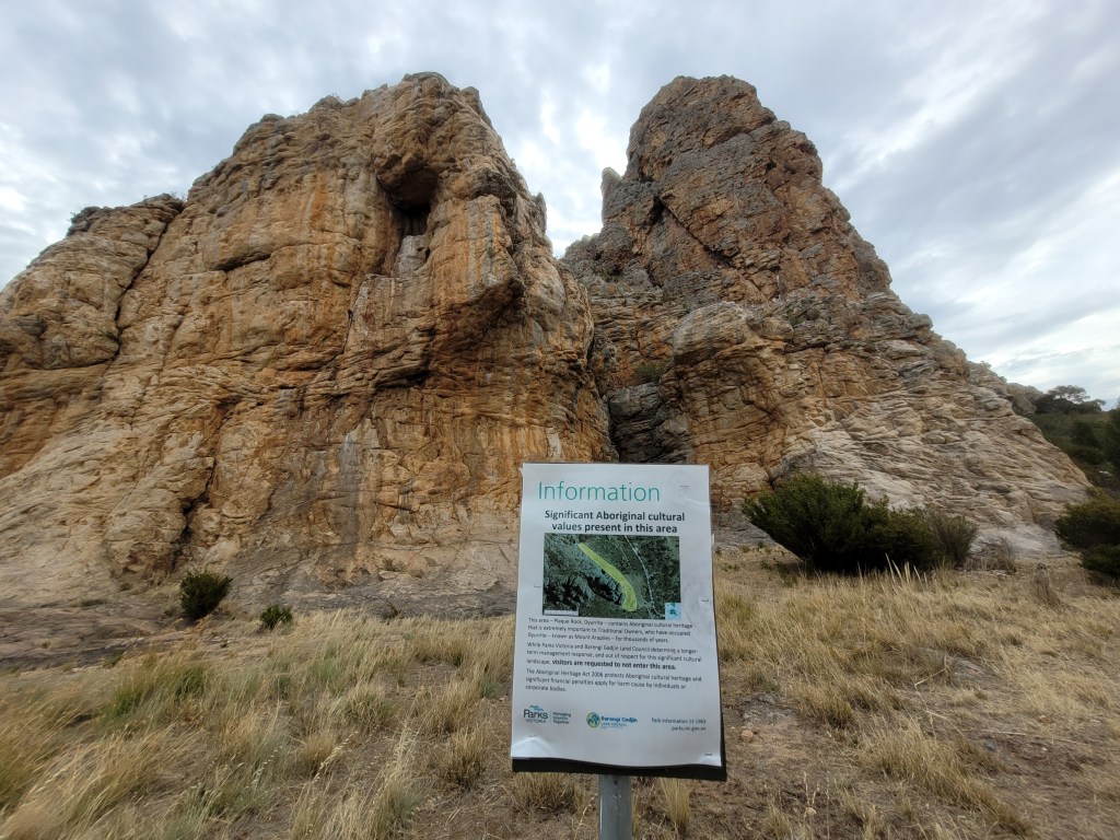
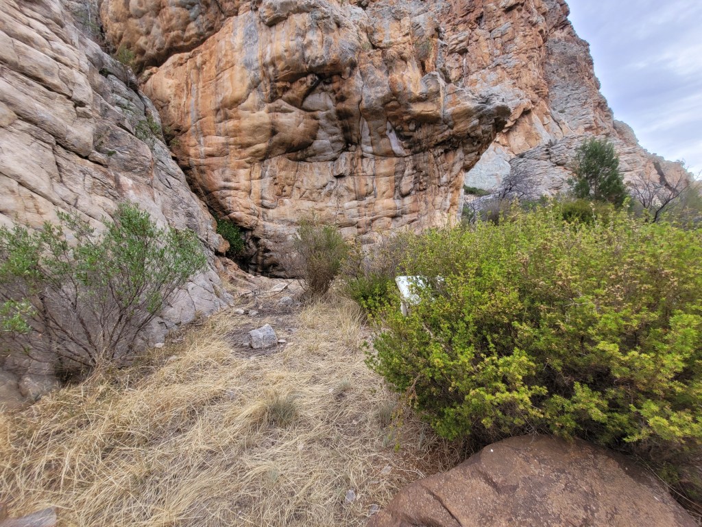
These shattered rocks at the base of Tiger Wall are why it is closed to climbing
Defining Intangible
The document helpfully defines what Intangible Cultural Heritage is according to Parks Victoria and BGLC.
“Intangible cultural heritage including stories, the beliefs and experiences of Traditional Owners and their position within the broader cultural landscape, and cultural knowledge of the landscape from ecological, chemical and cosmological perspectives.” – p.5
Chemical? No idea what that is about. There is no information given on what climbing areas are to be closed because of this intangible heritage. The climbing community may be losing the very best climbing areas in Australia over concerns around “cosmological perspectives” and we would never know.
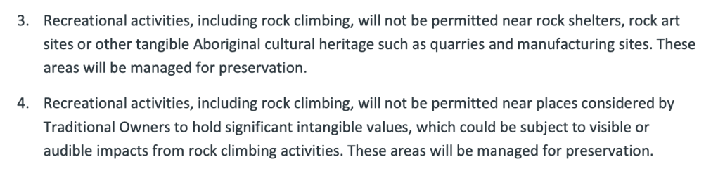
Quiet! Climber’s noise offends and creates bans
“Recreational activities, including rock climbing, will not be permitted near places considered by Traditional Owners to hold significant intangible values, which could be subject to visible or audible impacts from rock climbing activities.” – p.5
We have all heard the occasional power scream from climbers at crags. When you are pushing yourself through maximum physical and mental barriers this is often the result. Sometimes it’s annoying sure – but does it warrant banning access because of it? Or maybe the tinkle of a bunch of swinging hexes is the offensive part?
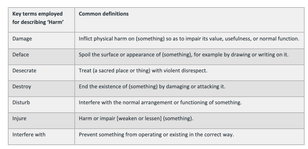
Looking at the definition of harm to Aboriginal cultural heritage helpfully included on page 10 it is hard to imagine how climbers making noise fits into any of these categories.
We think climbers everywhere should be aware of other users of the parks we visit and make sure that our actions don’t distract from others enjoyment. If that means toning down the screaming – and leaving portable music at home – sure. That doesn’t “sound” hard to achieve if our very access to public land is at stake. We have no reference if this “audible” concern has closed any specific climbing site at Arapiles.
Mapping
A little snippet down the bottom of page 5 is interesting –
“The existing climbing area polygons (Sourced from Mentz, S. & Tempest, G 2016 Arapiles selected climbs, Open Spaces Publishing, Natimuk) currently represent the most practical boundaries for achieving these objectives as they comprise the best available data and were the units used for recent systematic values assessments. Their use as proxy settings will also significantly reduce the size of buffer zones that were adopted for the 2019 Special Protection Areas. It is expected that in future, the management units will be re-configured to better align with Aboriginal cultural values, places and landscape features in line with Traditional Owner expectations.” – p.5
Not sure what that means exactly – but it appears sometime between 2021 and now they switched to using thecrag.com for mapping. It is unclear what they mean by the management units being switched to better align with Traditional Owner expectations. This seems to confirm that any “final” decision is not final at all and PV and BGLC can change it on a whim if required. Of course if climbers ask for changes that will be impossible but.. yere. We saw that in the Grampians where the popular beginner area the Mountain Lion was deemed a designated climbing area in the formal signed off management plan – then this status was almost immediately revoked upon the instructions of the Traditional Owner groups in charge. Nothing is as permanent as change.
If it’s all too hard to deal with – then it’s banned
Remember how Parks Victoria funding has been cut, staff reduced and the whole organization is likely to be homogenized back into the State government ministers control? That may not be a good thing if they really want to stick to the rules they have made for themselves with this document.
“Where the land manager does not have the resources to actively manage a site or implement agreed mitigation measures where values are present, the site will be closed to rock climbing until such time that these management actions can be implemented. Resources will be actively sought to support implementation.” p.6
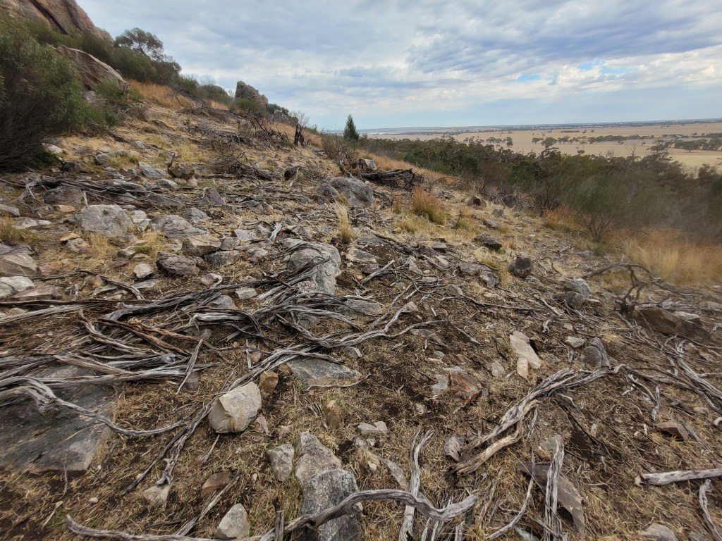
Without a significant funding upgrade – that includes more staff than one lone ranger visit every couple of days – they have no hope of “managing” the climbing at Arapiles in the way they propose. Even if they decide to go the full legal threat of “set asides” there appears to be no one around to enforce them. A recent visit to Arapiles by our contributors saw many examples of missing signs and overgrown vegetation obscuring known Aboriginal art sites – and being a legit fire hazard for those sites. They even saw clear evidence of a fox or feral cats living directly under one of the most significant quarry sites featured in recent mainstream news reports. If they can’t manage the smaller bans now – what is the plan for when they quadruple them? If the Grampians is any example it’s likely they just give up quickly and move onto areas that require major management like pest species eradication and bush fire control. Where is the “joint manager” BGLC who is charged with looking after these sites?
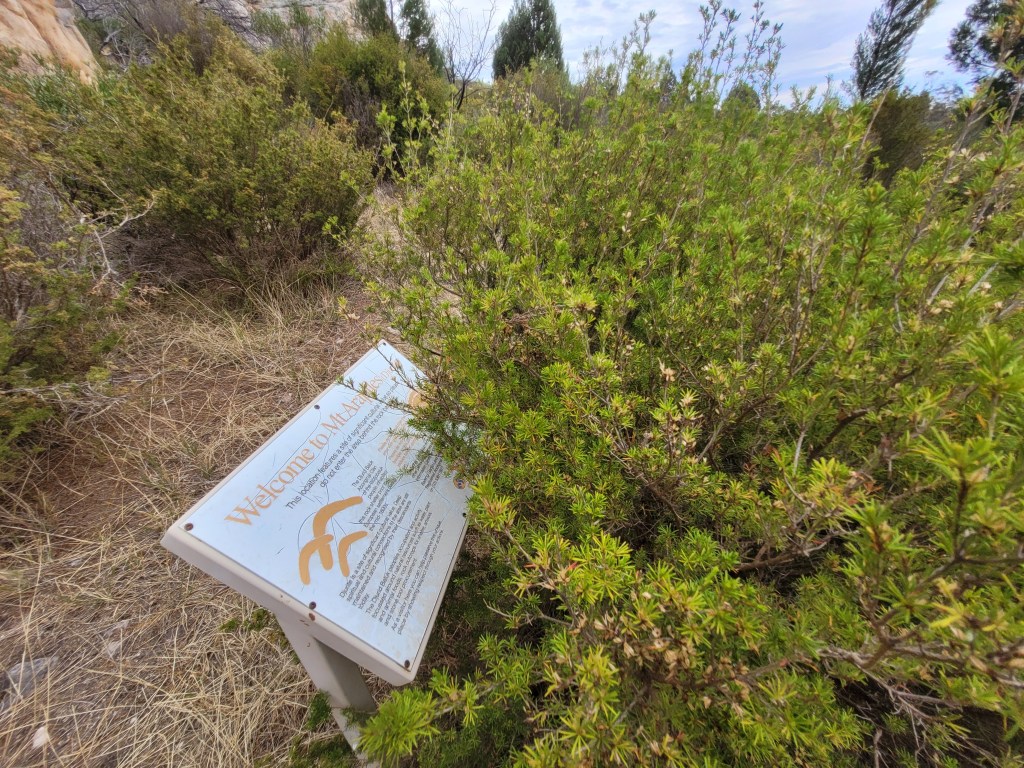
Sign entirely obscured by vegetationSign entirely obscured by vegetationMissing signage – it looked like this for over 2 weeksExamples of lack of management of Arapiles – Jan 2025
Climbing history and importance is not factored into “decision making”
What is missing in this document is critical. We all know this by now but it’s good (bad?) to see it so clearly in this document. There is no mention of researching or defining the value and contribution that the proposed closed climbing areas may have to the wider community. No “values” placed on specific routes, walls, rock formations. No mention of historical value of rock climbing to many thousands of people over many decades. Climbing is defined as a nuisance not something with a rich heritage of its own.
This is the proof that the importance of Arapiles to the international community was entirely disregarded by all land managers when making “decisions” on what is banned and what remains opened (less than half).
Also there is no mention of how this decision would impact the wider region economically, socially and health. We now hear of important professionals leaving the region in anticipation of the imminent bans.
PV and BGLC were so focused on the rock in front of them they didn’t see the “forest” of climbers and the wider community around them. It is clear they just knocked off access to climbing areas one by one but didn’t consider the wider ramifications of the end result – the closure of more than half of the internationally significant climbing areas at Arapiles. By the time they finished the report and put it together using their “framework” it was probably to late – they had dug themselves a big hole and couldn’t back out of it. Even some members of GWRN were shocked by the end result.
Flexibility
We all know if it was the government that was building a new walking track, road, hotel there would be acceptance that some harm may occur for the larger benefit to the community. Everything is a balance and tradable. When Parks Victoria chops a new track through the bush they know they are not “protecting” the environment but giving recreational users better access to the park. This does not seem to apply to rock climbing.
The document hints at some flexibility such as “seasonal closures” – but these don’t appear to have made it into the final plan.
“Seasonal rotations based on management capacity and landscape impact/recovery and ability to undertake cultural practices will be considered in the decision making process and implemented, if appropriate.” p.6
There will be no further growth in rock climbing – that’s “colonialism”.
That is Park Victoria’s words not ours – as clearly spelt out in their Decision Framework document on p.5
According to the Decision Framework – all new climbing post 2020 is considered invalid and will not be supported. Imagine if this principle was applied to bush walking, bike riding – or any other park development such as car parks, toilet blocks or signage? Imagine if the construction of the Grampians Peaks Trail was spoken off as an act of “colonialism”? No other activity in singled out in such a way as rock climbing. Remember that community net positive activities such as climbing festivals or events are not to be allowed either. In activist’s (sorry – “government employees”) eyes climbing is a colonial expansionist enterprise that needs to be quashed. Does such an extremist and partisan viewpoint have any place in what should be a boring piece of public service paperwork? The word colonialism is shorthand for “racist” – probably the harshest word that can be thrown at someone in these times. Language matters. In 2025 this is what the Allan Labor government supports.
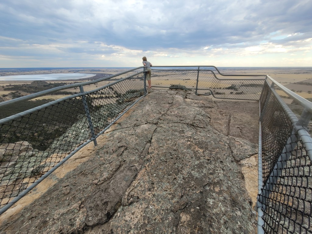
Would upgrading the summit lookout be deemed “colonisation”?
It’s interesting to see how this document is written – according to the document it’s not the potential opinion of a few individuals in the Aboriginal community that climbing growth is colonisation – it’s written as a given that it is ALL Traditional Owners who have this view point. We know that is simply not true – there are people within the climbing community with Aboriginal ancestry. How well informed were these Traditional Owners in making this decision? They “perceive” this as an issue but did anyone explain to them what it actually means? Do they realize that the vast majority of climbs at Arapiles involve no installation of safety bolts, no potential vegetation or heritage disturbance and “leave no trace” is often the end result? It is the act of hands and feet on rock – like their ancestors probably did for thousand of years without the aid of modern climbing equipment. Someone being present on a bit of rock is not “colonialism” unless you have a bias against that persons ancestors. Moving over rock is something enjoyable that comes naturally to all of humanity and is enjoyed all around the world. Defining when bush walking ends and climbing begins is actually incredibly hard. Just what was told to the Traditional Owners when they agreed with the principle of no new growth of rock climbing in this document?
And what research did Parks Victoria do to define what had been climbed up to 2020? We know they didn’t ask any of the current and past climbing guidebooks authors such as Glen Tempest, Simon Carter, Louise Shepherd or Gordon Poultney. They relied entirely on thecrag.com as their “definitive” list of what had been climbed. We have explained in detail the flaws of relying on such publicly created material – which is chock full of misidentified geographic areas, missing routes, duplication and such. Since the climbing bans started being rammed down the throats of Victorian climbers in 2018 the majority of new crag developers Australia wide have now refused to use thecrag due to the fear of the information being used against the climbing community. It’s a well founded fear. thecrag.com is not a source to be trusted about what has previously been climbed.
When they talk of colonisation do they consider what their heavy handed management plan is having on the free spirit of the rock climbing community? A government who has little understanding of what they plan to manage and even less willingness to incorporate it into decision making processes dares to “colonise” the rock climbing community. See we can also use that word way out of context.
Start again PV.
This document is a farce of navel gazing drivel driven by political views and does not match community expectations of fair access to public land. Let’s hope they take the data they have acquired through years of expensive surveys and rethink the whole management principle of “declared climbing areas” and instead consider closing smaller areas whilst allowing free and fair access to Arapiles and the Grampians wonderful natural environments for generations to come.
The Dyurrite Cultural Landscape Management Plan Amendment doesn’t actually list what climbing areas and routes it is closing. It’s clever like that. It only lists the “designated” climbing areas – and pretends all the other stuff simply doesn’t exist.
Here at SGC we are publishing a list of the classic areas and iconic routes that the Labor Allan Government, Parks Victoria and BGLC doesn’t want to talk about. This list includes famous routes such as the world’s first grade 32 – Punks in the Gym, the best super easy route on the planet Tiptoe Ridge (5) and even Kachoong (21) – the hugely popular roof route that made Arapiles famous.
For over 4 years Parks Victoria and Barengi Gadjin Land Council (BGLC) have been working behind closed doors to formulate a plan to close more than half of the Mount Arapiles-Tooan State Park to all recreational users. This is a piece of public land who’s main users, up to this point, have been rock climbers – well over 50,000 a year and they make up more than 90% of the visitors to the park. These recently announced restrictions on access include some of the worlds largest climbing bans and eliminate thousands of individual climbing routes – many considered to be irreplaceable by the climbing community. Read the details of their plan here.
This article covers some of the ways that community consultation regarding these bans has been either ignored or manipulated to create a an end result that Parks Victoria and BGLC want.
Parks Victoria has announced community consultation about this plan on its Engage Victoria website – a familiar platform if you were around during the Grampians bans.
Have they “engaged” with the community in this journey? No.
WE NEED YOUR HELP – go to our call to action page for ideas on how you can help overturn these bans.
It’s now blistering across the socials – the Allan Labor Government, Parks Victoria and Barengi Gadjin Land Council (BGLC) have announced incredibly harsh and destructive climbing bans to more than half of the climbing areas at Mt Arapiles – considered the best rock climbing area in Australia and the worlds best trad climbing destination. In their usual cynical and compassion-less approach they announced this with no consultation, no warning and at 5pm on the night before a public holiday. Throwing out the garbage is what the media call this.
This article will hopefully cast some light onto this recent announcement and the “amended” Management Plan for Arapiles and give some background for anyone who isn’t up to date with what’s been happening to Victorian rock climbing in recent years (TLDR: the government and Traditional Owner corporations have burnt it to the ground). Make sure you do your part to overturn these bans – check our call to action page here.
Key points about the new climbing bans at Arapiles
Ban on 63% of Arapiles rock climbing routes applies on day 1
Plan is a right royal hatchet job against climbers (and appears to also be a bungled rush job with many errors)
Plan modifies conservation zone definitions to ban climbing
Plan prohibits new routes and walking “off track” – even for bushwalkers.
Plan introduces “designated areas” as the only approved climbing locations – removing half of previous climbable terrain.
Recreational activities will not be permitted near cultural heritage. How close is “near” is not explained.
Rare plants may have triggered some bans despite not being listed as a vulnerable or endangered species.
Promised million $ funding from government will do nothing for rock climbers
Labor Government, Parks Victoria and BGLC refuse to acknowledge pain and suffering to community from rock climbing closures.
Aboriginal traditional owner group promises it’s moving back to Arapiles and has little sympathy for climbers use of the area previously
There will be little community consultation from Parks Victoria about these bans – they don’t want to even talk about the areas to be banned
Reconciliation group with climbers as members used as a political weapon against climbing community by the Labor government and PV. It’s far from reconciliation.
Climbing groups believe these closures could be reduced dramatically with smaller area closures as has been done in the rest of Australia and the world. This would not result in a reduction of cultural heritage protection.
Political and legal action is inevitable – something has been triggered amongst the climbing community which has never been seen before.
Many climbers are questioning their long held political beliefs and thinking. Political allies are being sought from all sides of politics (if you are a politician and reading this – be warned that your safe hard-left demographic may not be as safe as you think)
The following is an in depth dive into the points above. It’s a very long read – maybe go make yourself a coffee first.
Arapiles? The best crag in world
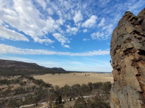
For those not familiar with the area – it’s simply described as the most loved, most popular and most famous climbing area in Australia. With 3300 routes spread across a cliffline that is entirely walking accessible from the campground – this is (or was) a climbing paradise. The climbs are world class and the density and variety of classic routes is hard to match anywhere in the world. The climbing is essentially all traditionally protected. There are a few bolts around, but they’re mainly on the harder stuff, and only in places where natural gear won’t suffice. Tens of thousands of visitors from interstate and internationally visit this area due to it impeccable rock quality, friendly campsite and well documented historical place in the global climbing scene. Climbers make up 90% of all visitors to Mt Arapiles State Park – with visitation levels exceeding 50,000 persons a year. Bonding this area together is a thriving community of like minded folks who have passed the baton from one generation to the next in looking after the place through a simple connection – rock climbing. If you jump on socials you can read page after page of people’s personal stories about their attachment to Arapiles, a place that has shaped and quite literally saved lives. If you’re a climber and haven’t experienced Arapiles you really need to. That was the past – what are we looking at now?
What’s at stake?
The recent announcements lock in a ban of 63% of Arapiles rock climbing routes on day 1, and moves to a permanent ban of more than 54% of the rock climbing routes some time in the distant future (if they find money to install new signs, tracks etc). Most importantly these areas are considered the best crags to climb at Arapiles – with the remaining areas largely not of a quality that makes them appealing to interstate or international visitors – especially if you are climbing at a high technical level. The bans also include areas considered to be the worlds best beginner routes – the nursery grounds for thousands of young climbers who have been introduced to climbing via school camps or climber parents. These bans are comparable to the worlds largest climbing bans that occurred at nearby Grampians National Park in 2021 – covered extensively on this site. Combined these two banned areas consist of the greatest loss to the rock climbing global community ever recorded.
And it’s not just about the climbing itself – the community that surrounds this area in the nearby town of Natimuk and the wider Wimmera area around Horsham will be financially affected for two reasons – a loss in tourist climbers spending in the region, and also a loss of residents – as many climbers reside in these areas by choice – moving there from other places in Australia. They bring much needed skills to regional western Victoria – medical professionals being one prominent group of local climbers. A reduction in climbing in the region means these people will leave.
You can read more about the economic impacts of climbing bans in a report made in 2021 – Economic Assessment of Rock Climbing at the Grampians National Park and Mount Arapiles. The report states that before bans were implemented in 2019 there was an estimated direct and indirect rock climbing tourism benefit to regional communities of $12.3 million for Mount Arapiles. In the first year of climbing bans in the Grampians there was a 36% decline in climbing person days. With these new bans in place this number will be plummeting even further. It makes the sugarcoated $1.7M the government has also announced to “do up” Arapiles infrastructure seem like chump change. It won’t scratch the surface on the financial losses that will occur from the bans.
Key dates up to this point
2005 – Barengi Gadjin Land Council (BGLC) becomes the anointed co-manager of Mount Arapiles-Tooan State Park with Parks Victoria. This gives them the right to make some management decisions about the park. Parks Victoria is expected to take on board any closures they propose.
2006 – Aboriginal Heritage Act introduced which introduces Cultural Heritage Plans, permits and creates Registered Aboriginal Parties (RAPs) which can now takes control of cultural heritage decision making. Read it here.
2017 – Wimmera and Grampians Indigenous Tourism Feasibility Study published by BGLC and Parks Victoria which details plans on how to monetize Arapiles through indigenous tourism. Read it here.
2018 – Parks Victoria Act introduced by Labor government. This gave independence to the organization which in turn gave them increased powers and greater responsibility to manage land under their control. They begin flexing their power. Read it here.
2018 – Aboriginal Heritage Regulations updated. This legislation requires Parks Victoria as the land manager to protect “values” from harm or they face legal and financial consequences for dereliction of duty. This appears to trigger the up coming bans. Read it here.
February 2019 – Parks Victoria announces sweeping bans to many climbing areas in the Grampians National Park – a major climbing area near Arapiles. This is in partnership with BGLC as they are one of three traditional owner groups. This eventually leads to closure of over 80% of the climbing and creates the world’s largest climbing bans. Much of this website is devoted to this issue.
June 2019 – In a post titled Is Arapiles Next? this website predicts that bans similar to the Grampians will spread to Arapiles. BGLC staff are quoted as saying “Climbers have had a good run for forty years; their time is over”.
December 2019 – Declaration Crag is the first area at Arapiles to be informally closed due to cultural heritage concerns. No climbing representatives were warned in advance, none were invited to the site to discuss ways of limiting such an extreme closure, and no further information was revealed about the exact location of the art and quarry site. See our post here.
March 2020 – Declaration Crag receives the first formal ban through a “protection declaration” with maximum penalties for contravention being a $297,000 fine for an individual. This was the first time this legislation had ever been used in Victoria (how lucky are we!). See our post here and a follow up post here.
August 2020 – World famous Grampians crags of Taipan Wall and Bundaleer added to the already extensive Grampians bans. Fun times discussed here.
October 2020 – Massive “temporary” closures of major areas at Arapiles announced that includes Tiger Wall, Castle Crag, Fang Buttress and nearby Black Ians Rocks. This was yet another pre-weekend late afternoon announcement from Parks Victoria designed to avoid media scrutiny. See our article here (depressed yet?)
November 2020 – Parks Victoria, in conjunction with BGLC and Gariwerd Wimmera Reconciliation Network (GWRN) begin comprehensive archaeological and ecological surveys of Arapiles with the end purpose of restricting access to climbing areas.
December 2022 – A new management plan for the Grampians National Park is released which bans 80% of the climbing in the park – and destroys access to the vast majority of iconic and difficult routes . The appeal to international and interstate visitors as a climbing destination is decimated. Read about it here and see the loss stats here.
February 2023 – Comprehensive archaeological and ecological field surveys of Arapiles are finally completed after more than two years. The results of these surveys are kept secret however.
October 2023 – Climbing safety bolts are removed by contractors at Millennium Caves in the Grampians. Members of the climbing community are paid by PV to complete this work. This action proves divisive amongst the climbing community. At the same time the referendum on an Aboriginal Voice to parliament is voted down by 80% of residents in the Wimmera district.
November 2024 – BGLC and Parks Victoria announce permanent bans at Arapiles after 4 years of rolling temporary bans. They add even more major climbing crags to the original ban list – this includes the Pharos, Yesterday Gully, Tiptoe Ridge and Mitre Rock. These bans now amount to more than half of the climbing at Arapiles. See our post here.
Early 2025 – this is the proposed date for when these huge news bans at Arapiles will come into legal effect.
“Temporary” bans have been in place at Arapiles since 2019
Announceables – or how to spin baby spin
Have a read of the lovely sounding press release that launched the bans into the public eye from the Allan Labor Government here. To quote the opening paragraph “The Allan Labor Government is ensuring Victorians can enjoy the Arapiles-Tooan State Park (Dyurrite Cultural Landscape), investing in its facilities and protecting its natural wonders for future generations to come..” Sounds great hey? ChatGPT would be proud of such PR waffle. They seem to have forgotten something though… just trying to put my finger on it…. ah yere. What about the ban to half the climbing – any sign of an apology, acknowledgement – anything at all – about the annihilation of the Victorian climbing scene within this announcement?? If they think they got bad PR from the Grampians climbing bans then they may get a rude and ugly surprise from this announcement. To rub further wounds they throw into this press release the tone-deaf word celebration (good times – come on!) with a jaw-dropping facepalm quotable from Labor Minister for Environment Steve Dimopoulos..
“We want as many Victorians as possible to enjoy the great outdoors. This investment will allow more visitors to appreciate the park, while celebrating and protecting its cultural and environmental wonders for future generations.”
Banning climbing is a sure way of doing the opposite of “allowing as many Victorians as possible to enjoy the outdoors“. Whoever wrote this press release has a total lack of empathy for the rock climbers who have already been hit around the head for the last 5 years with extensive climbing bans in the Grampians and Arapiles. It makes the idea that if climbers “behave” the cyclic bans will stop seem comical. As many commenters on social media have stated this fells like a betrayal of public land usage and a deliberate and calculated punishment for climbers. And those are just the words that don’t involve C and end in T. It feels like the government has just announced the flooding of our climbing village and they want to celebrate the dam builders. A traumatized climbing community is not an exaggeration. I’m sure we can just let them know they did bad and they will change it all won’t they? That’s not how they work…
Million dollar investment?
The other big announceable in the press release was a funding boost for Arapiles – a one off infrastructure injection designed to sweeten the great deal climbers are getting from the government.
“The Victorian Government has announced a $1.7M investment to improve the facilities, tracks and access points at Mount Arapiles… [snip] Planned upgrades to visitor facilities include new barbecues and picnic tables, improved parking, refreshed tracks, and trails that will make the park more accessible for people, including signage telling the remarkable cultural story of the area. Outdated toilet facilities in Centenary Park will also be replaced.”
No one asked for this. This is clearly an example of political spin – a meager financial announcement to make the press release a “positive” one so they don’t have to talk about the real financial damage these bans will do to the regional Horsham community. For decades Parks Victoria has proposed upgrades to Arapiles which the climbing community did not ask for – back in 2019 Simon Talbot from PV even proposed installing hot showers (and bumping the camp price up to $30+ a night to match the Grampians). That was roundly rejected. Climbers are very happy with the status quo – a cheap rustic camping experience with a communal flavour. But climbers are not what Arapiles is supposed to be known for now….
You know who will benefit from this $1.7M? BGLC. They have welcomed the funds headed their way which will top up the last round they got for two years of cultural heritage assessments (anyone want to FOI what that cost?)
“The funding will help us protect Dyurrite’s unique cultural heritage” – Lyn Mace BGLC Deputy Chair.
BGLC’s multimedia spectacular
The climbing community got another PR hit around the head two days after the government announcement when BGLC released a polished website titled simply Dyurrite. Clearly this was something that has been in the works for many months and designed to twang at those heartstrings. It’s a slick piece of professional multimedia and includes a 10 minute video that’s absolutely worth a watch. Drone shot over the summit… soft music, kangaroos – what a spot. If this video was all you ever knew about Arapiles you would be thinking – what’s all the problems people keep talking about? Doesn’t everyone just want to walk together with a mutual love for shared values and land etc etc. Of course it doesn’t include any climbers input – we are simply vaguely refereed to as “recreational users” at one point. What is made clear is this is a return to a place that the Aboriginal community haven’t had much involvement with in recent times. At one point they refer to taking out the bookmark and turning a page in history. It’s actually a pretty powerful little film.
Where it goes a bit off is some of the quotables on the rest of the page – one that we have seen used before against climbers is Stuart Harradine’s classic line that climbers are “drilling bolts into the bones of our Creation Ancestors” (he means the rock). It’s a claim that strikes us as hypocritical when BGLC is talking up “one of the largest stone manufacturing sites in the world” and also scar trees nearby which are part of their cultural heritage. Humans have impact – the roads and the Telstra tower are examples of seemingly ok modern additions. The $1.7M is to be used to construct a toilet block and picnic tables on parts of the Creation Ancestor. Arapiles as a climbing area remains an island of natural sanctuary in a clearfelled wheat belt. No one wants to see climbing bolts in Aboriginal rock art sites. No one wants to see the destruction of quarried areas. We think it could be phrased in a slightly less dramatic way but suspect the target audience is not climbers.
Cowardly Community Consultation
The government hates honest feedback about their “brilliant” decisions. For some humor go and watch the brilliant TV show Utopia’s take on Community Consultation. That’s pretty much what we have here when Parks Victoria gets involved.
No actual climbing organization was consulted about these climbing area bans at Arapiles. Climbing Victoria, (the peak body representing outdoor climbers in Victoria) and the Australian Climbing Association Victoria were both blindsided by the announcement on Melbourne Cup Eve. These bans are presented as a done deal – in PV’s own words.
“We want your feedback on the management plan amendment. You have the opportunity to provide input on how you would like to receive information, improve map and guideline accessibility, update signs, or use chalk. It is important to note, this consultation will not be reviewing any changes to the areas that need to be protected.“
Errr what? That’s not how consultation works. The crux of the issue for the 90% of current users of the area (i.e. climbers) is how much public land is being locked away – and the reasons for this closure. This is the number 1 issue that people have here. It’s doesn’t get much bigger for a land manager that is supposedly managing public land for the public good to be then removing public access. How can this not be part of the so called “conversation”?
The only future consultation mentioned on the Engage Victoria website are a simplistic survey (that does not deal with the impact of these bans) – don’t bother doing this, an ability to upload a written proposal (do this!) and one online Microsoft Teams meeting on the 13 November. Do you think this Covid era zoomy will be our one last chance to have a real say face to face with people in power? That will be a no.
Note it is NOT actually a community consultation event – its an “online community information session“. They will tell us how it is – and we have to sit there and take the beating. We might be able to tell them our preferred colour of chalk (seriously – this is one of their question in their survey!). Unlikely that any proper questions will be taken – and certainly no feedback from this online event will be collated nor will this change the final plan to any degree. They certainly don’t want to talk about reviewing what areas are to be banned.
The cowards in all of these organizations behind the bans hide behind one-sided media releases and refuse to front up and talk to real affected people in the climbing community-and the wider regional businesses that rely on climbing tourism. Their press releases glow with positives and refuse to acknowledge the mental and financial burden that these actions will place onto the climbing community. The destruction of the community of Natimuk appears to not be factored into this decision at all – but is the inevitable result. Warm your cockles with a look at an old episode of ABC’s warm and fuzzy Back Roads that features Natimuk pre bans.
Deconstructing the plan itself
Enough ranting about the press releases – let’s explore the plan itself. Download a copy of the document below that explains the destruction of climbing at Arapiles – the Management Plan for Arapiles.
This is advertised as an “amendment” to the positively ancient 1991 Management Plan for the Mount Arapiles-Tooan State Park. The scope of the amendments are “made in accordance with Section 47 of the Parks Victoria Act 2018, focuses on the protection and management of cultural and environmental values.“
Here we state the unsaid and obvious. When PV write the words protection of “culture” they mean one type of culture – Aboriginal culture at the exclusion of all others.
The amendments are marked in red throughout the new document – whilst the original 1991 text is in black. Within the remaining black text is plenty of seemingly outdated and irrelevant items – it’s showing every bit it’s 33 years age. The opening page even admits as such
“Please note that information in the 1991 plan that is outside of this scope remains unchanged, including language and concepts that Parks Victoria recognises are outdated in 2024“
Is this a rush job to get climbing banned so Parks Victoria doesn’t get sued by BGLC? You bet! There are so many simple items in the old management plan that could have been dealt with in the same 2024 amendment – but continuing a hyper focused approach on removing climbers is clearly plan A at PV and BGLC. There are elements that freaked climbers out (eg the closure of The Pines campground) that may not actually be happening as they are leftovers from the 1991 plan, and somehow we are all supposed to know are irreverent in 2024. Confused? You should be. That’s probably the plan. Below we will try and break down various relevant passages in the amendments – and mention some of the remaining text from the old document which still concerns climbers.
Stated reasons for the climbing bans
The opening of the document devotes half a page to the reasons for the rock climbing restrictions. It’s helpful to understand this.
“The Mount Arapiles -Tooan State Park (Dyurrite Cultural Landscape) has biocultural significance. Recent rediscoveries including scarred trees, rock art with evidence dating back 3000 years, and one of the largest stone quarry complexes found in Australia demonstrate that Mt Arapiles (Dyurrite) has been a significant place for the Wotjobaluk Peoples for tens of thousands of years.” page iii
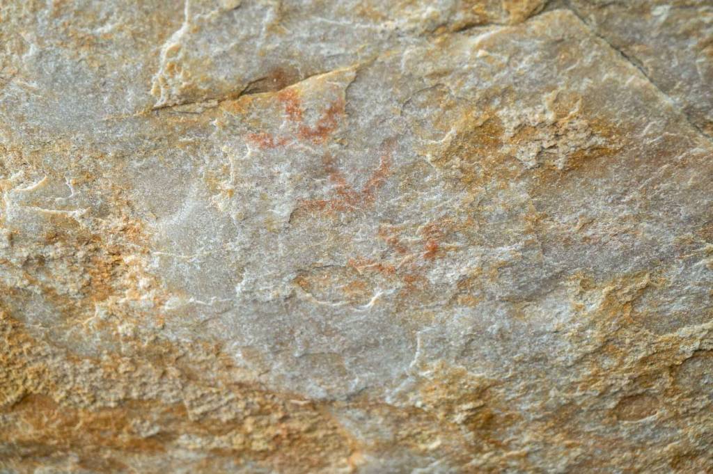
At least they aren’t claiming its 250,000 years old. If you are imagining the extensive rock art panels of the Northern Territory, or even the comparatively smaller panels in the Grampians you will be very disappointed by the rediscovered rock art at Arapiles. Most of the art is so faded it is invisible to the naked eye. Some of the press releases around the Declaration Crag closure in 2020 spoke of “50 rock art motifs across several art panels” – but they have never supplied imagery of this art and no one appears to have clear photos (for the very reason its invisible). It’s easy enough to walk around the boulders in front of Dec Crag and look for yourself – as that is the main claimed art site. Sources we have spoken to say there are only about half a dozen art sites at Arapiles and that five of them are not near climbing routes – and the sixth is tucked away enough it has not been damaged from climbers despite 60 years of use. Do they have historical and scientific value for everyday Australians and need protecting? – Absolutely. Do they have importance to traditional owners for reasons far beyond the above – most certainly. What remains of their presence at Arapiles is incredibly fragile, faded and irreplaceable.
Example photos of two art sites at Arapiles – very hard to see with the naked eye. Neither have been damaged by climbers.
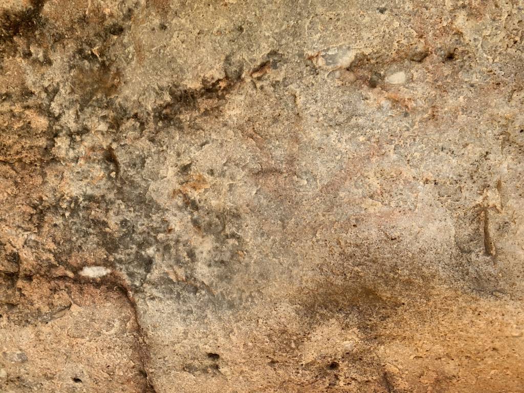
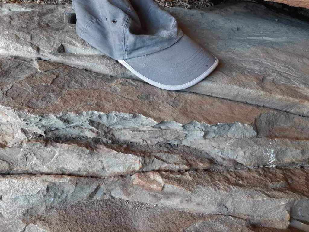
Then there is the claim of the discovery of “one of the largest stone quarry complexes found in Australia“. We presume they mean prior to the arrival of Europeans. This “quarry” is an area of chipped off stone that runs along the base of Tiger Wall, and in the proximity of various other cliffs at Arapiles. It consists of broken stone edges and has not been damaged by climbers as it is hard rock – the very reason it was both used for creating stone tools, and is an excellent climbing medium. According to elders of the Natimuk climbing community these quarries had been put onto the Victorian register of aboriginal heritage back in the 80s, with no concern about the impacts on it from climbers. They remember walking the cliff with members of the Aboriginal community and everyone being happy with what they saw. These same stone quarries are all over the tourist tracks in the Grampians – there is one right on the walking track to Hollow Mountain. This has been pointed out to Parks Victoria on numerous occasions and they have never acknowledged the hypocrisy of banning climbing because of stone tool quarrying in one place whilst promoting hikers to walk over the same thing elsewhere. Remember in PV logic tourists wear special shoes that make them float above the ground. Do each and every one of these numerous stone tool quarry sites at Arapiles require such a level of protection that exclusion zones from now to eternity are required?
Rock scars from Aboriginal tool quarrying on the cliff below Pilot Error
The plan intro continues…
“These surveys rediscovered and registered cultural heritage, confirmed the existence of threatened plant communities, and revealed widespread environmental impacts. In response, it was determined that the 1991 Mount Arapiles-Tooan State Park (Mt Arapiles Management Unit) Management Plan would need amendment to facilitate the popular activity of rock climbing while ensuring the protection of park values for the whole community” page iii
Gotcha. Climbers out. We have to remember in Victoria that tourists, bushwalkers, cyclists, bogans with beers and highliners all have no capability of harming anything. In fact they can freely do what they want and require no special mention in this new updated management plan.
Who’s really in charge?
One of the first major red inserts into this amended document is the mention of Barengi Gadjin Land Council Aboriginal Corporation – an entity that did not exit in 1991 when the original document was written.
“The Mount Arapiles -Tooan State Park (Dyurrite Cultural Landscape) is managed by Parks Victoria with the support of Barengi Gadjin Land Council Aboriginal Corporation…… Barengi Gadjin Land Council’s status as a Registered Aboriginal Party under the Aboriginal Heritage Act 2006 provides the right and legal responsibility to Care for Country, and to be recognised as the primary source of advice and knowledge on matters related to the protection and management of Wotjobaluk cultural heritage.” Page 2
We have heard from various people, including GWRN, that it is BGLC that are making the decisions about what areas are to be banned and what stays open – and PV is just following their instructions. GWRN itself has said they don’t actually talk with PV at all – and that all their discussions are with BGLC – this includes a secret 54 page document that GWRN wrote and presented to BGLC with their recommendations. As BGLC is not part of the public service it is highly unlikely that any kind of Freedom of Information search can be done on their decision making process. Another nail in the coffin for transparent management of public land. We simply do not know the details.
thecrag.com used against us – again
“the single most accessible data source concerning climbing areas and climbing routes is available on the Crag Website (www.thecrag.com). This community-based platform provides information in accessible spatial data format.” page 2
Don’t get me wrong – we love that website. But we see on page 2 another example in where it is being used by land managers to map and restrict climbing areas without leaving the comfort of their air-conditioned inner city office (just a short electric bike ride away from the theater!). They would find it much harder to show what is open or closed if they didn’t have it all mapped out for them by the climbing community in advance. Side note – it’s odd that on the same page it still keeps the old 1991 text stating there is 2000 routes at Arapiles – the current figure (according to thecrag!) is 3,306. 1,000 of them worthless linkups and boulder problems probably (we jest).
A belated update
Page 3 mentions that the 1991 “Plan is intended to guide management for a period of 5 years” and that “The Plan may be amended if, after adequate investigation, there is justification for the alteration of management based on additional resource data or new techniques“. So don’t let PV tell the climbing community that these plans are set in stone. They can be amended – just like we are seeing with this 2024 version! PV might tell us this is the end of the discussion but that is simply not true. The fact it has taken them 33 years to do the first amendments is laughable. At least this time they didn’t have to get the typist to fax a copy of the amendments to head office.
Out with old, in with the new
There is some optimistic words about rock climbing on page 4 in the 1991 version of this document that still remains…
“Visitors numbers, particularly those associated with rock climbing, are expected to continue to increase. Opportunities for recreational experience in a largely undeveloped environment will be maintained.” – “Rock climbing will continue to be encouraged as a major recreation activity. An additional camping area adjacent to the present one will be developed for rock climbers and other visitors. The simple character of existing camping facilities will be maintained, to preserve the experience of camping in the bush.” Page 4
Not sure we are seeing any signs of encouragement of rock climbing from Arapiles land managers these days… the reference to a new campground is actually something that came to fruition in the late ’90s with the opening of the Gums campground. Another example of text that should have been removed to avoid confusion in this 2024 amended version.
They did insert a new principle management decision that singles out climbers again…sigh.
“The principal management direction of this (draft) amended Management Plan is to enable rock climbing to continue within the Mount Arapiles -Tooan State Park (Dyurrite Cultural Landscape) in a way that does not harm cultural and environmental values.” page 4
At least it’s not a total ban.
Management Principles
Principled management – a novel concept when PV is involved. Page 5 has a couple of inserts relating to adding the word “cultural” into a few key points – meaning Aborignal culture once again. We don’t understand what exactly is behind this trend of creating “Cultural Landscapes” instead of National or State Parks. Must be a holistic view through the eyes of traditional owners that includes areas outside of hard legal borders. It appears a very human history centric view of these places – instead of the original nature conservation based approach to National Parks historically. These places contain rocks hundreds of millions of years old, and plants and animals that evolved in these places when dinosaurs were still around. There is a modern fascination with putting the First Fleet on a timeline against when Aboriginal people first arrived – but try putting any humans against an echidna that appeared 50 million years ago and you will quickly see our insignificance as a species against the wonders of deep time. Enough philosophy…
Page 5 still includes the refreshing old line that a key management principle at Arapiles is to “provide for rock climbing as a major use” [smiley face emoji] – but then adds in a new red amendment “in a way that does not harm cultural and environmental values” [no shit sherlock]. Every time they add one of these types of amendments in it is cold wet slap across the face for climbing credibility. As a user group this special mistreatment is extraordinary. Imagine if they said every time they spoke of bushwalking that it has the addition after it of “in a way that does not harm cultural and environmental values“. Harm is harm no matter what the activity.
And this is where the fun ends in the plan.
The Bans – flipping the script
A simple 8 word line changes everything.
“allow rock climbing activities within designated climbing areas” page 5
Just like they did in the Grampians in 2022 – Parks Victoria has flipped the script – instead of publishing a list of banned areas for rock climbing – they instead ban all climbing outside of “designated” climbing locations. This is a two pronged devils tongue approach…
1, they don’t have to list the banned areas in any documents – so they immediately erase any historical record of the once hugely popular climbing areas. Remove the evidence, wash their hands and pretend it never existed. You won’t read the words Castle Crag, Tiger Wall, The Pharos in this new plan – it’s like they never existed.
2, Managing a small amount of cliffs is easier. What land manager actually wants to walk around the land they manage? It’s easier to just fence it off, install butt ugly signage and let the weeds grow free. Save money, saves hassle. This usually applies to remote or hard to access areas that land managers can’t easily get to.
But what does that mean for climbers? Firstly any new climbing areas are impossible to establish – it’s not an approved area so banned automatically. They have made it clear in the plan on p. 27 that “New climbing areas cannot be established.” Anyone who likes exploration, quietness and obscurity will be forced instead to only visit a select list of 80 approved areas that will inevitably be busy.
Danger Zone
Then we get to another clever trick by Parks Victoria to remove climbers. Zoning! [Hope you haven’t zoned out by this point in the article?]
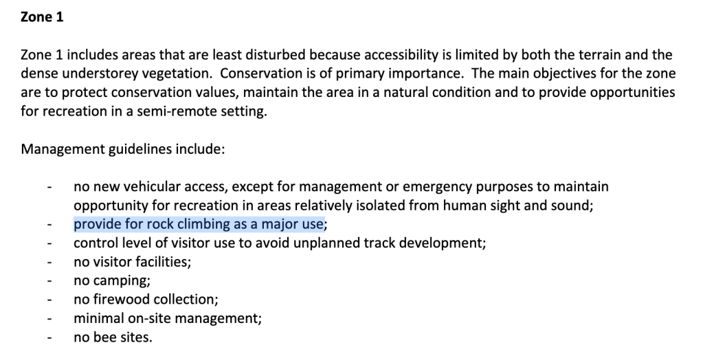
In the 1991 plan of management there were 3 zones described – and zone 1 was considered the highest level of protection – no new roads, no camping, no firewood collection. The basics. But it clearly stated that climbing ok – in fact it was another “provide for”:
1991 version of the plan of management to Arapiles
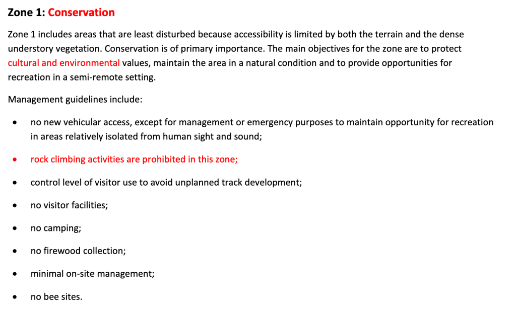
But if we look at the 2024 amended version of the plan – suddenly Zone 1 is rebranded as a “conservation zone” and is now off-limits to climbing as a prohibited activity (feel free to highline, pogostick, cartwheel etc at the cliff).
This is where a finer grained approach could be applied by BGLC and PV. Instead of banning climbing all together at long used climbing areas they could ban new bolts, new routes, white chalk. Where are Zone 1 sites?
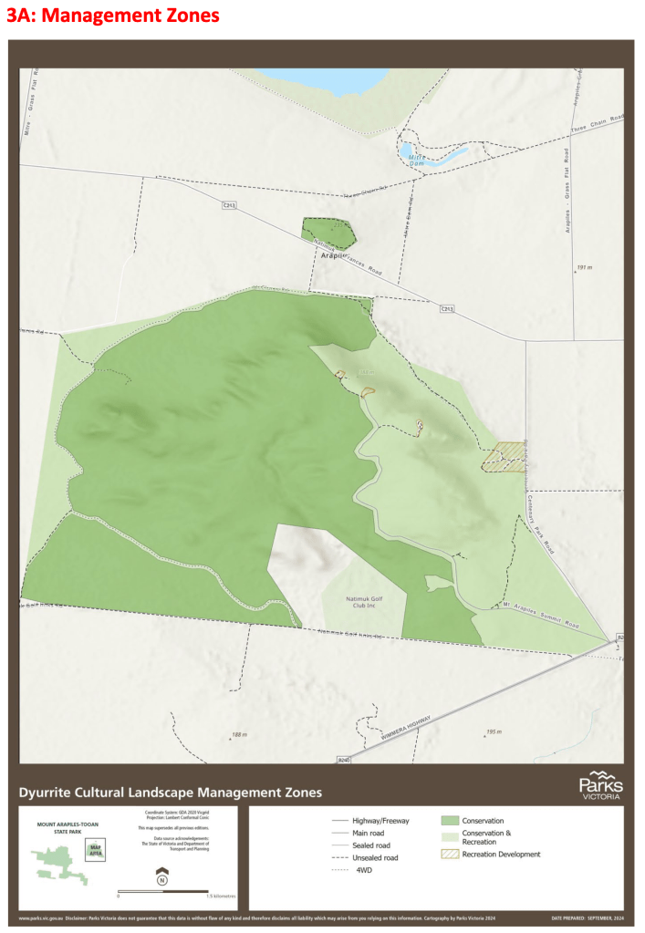
Let’s look at just where this Zone 1 “Conservation Zone” includes and how that simple decision to remove climbing from there will affect climbing closures. Zone 1 is the dark green colour on the map below.
Mitre Rock (127 routes) and Western Side (199 routes) are immediately banned. The former is a very popular beginner area and heavily used by guiding companies – especially since the demise of Declaration Crag, Plaque Area with earlier bans. Classic beginner routes such as Exodus (6), Guiding Light (6) and The Bishop (11) are now to be “conserved” forever. Western Side is chock full of obscure wilderness trad climbing – long walk ins, no tracks and with a much more Grampians feel. Does climbing currently impact this area? No. It’s just lazy management to re-zone this into a permanent ban.
Endangered Species
No, we aren’t talking about climbers here. One of the rarely mentioned factors is the additional bans caused by climbing being in the proximity of endangered species. This seems squarely in the court of PV’s management decision rather than BGLC – but since it’s all behind a culture paywall who knows.
Environmental surveys were done around the same time as the cultural heritage surveys (2021 to 2022) and they identified threatened vegetation species in the park. The new 2024 plan adds in the usual rock climbing is bad lines “Recreational Rock climbing will be actively managed using a ‘designated climbing areas’ approach to minimise the impact of this activity on native vegetation.” There is a little sneaky bit of text they added down the bottom of page 10 to further kick the boot into those naughty climbers “Archaeologists and ecologists recorded evidence of damage to native vegetation within climbing areas, during field surveys between 2020 and 2023” – note it does not say this vegetation was threatened or endangered. Have climbers actually had significant impact on vegetation in the park? Bushfires – natural or deliberate – wipe out acres of green but climbers deserve the special mention again.
We do not know what crags are closed because of threatened or endangered species but it seems likely that it has been done because of these additions to the management plan. Rumour has it that the entire of Yesterday Gully may be now closed because climbers reported the existence of a Skeleton Fork-fern (Psilotum nudum) in the gully. Looking at the paperwork regarding this plant it is classed 3 levels down – it is not endangered or vulnerable – but only “Rare in Victoria but not considered otherwise threatened.” Better hope Yesterday Gully isn’t shut for that then.
It would be great to have a nice big ID photo chart of plants to look out for in the Pines campground wouldn’t it? Perhaps they can allocate some of the $1.7M to that.
Falcons
Interesting to read page in the original 1991 text there is extensive notes about formally managing Peregrine Falcon nests and rock climbers. Of particular note is “The Victorian Climbing Club and other key user groups will be advised in writing of the dates of any closures and re-openings. Signs advising of any closure will be erected in the Park… Surveillance of any closures will be undertaken. If voluntary measures prove inadequate, legally enforced closures will be introduced
We are not aware of that happening at any time in recent memory – the climbing community appears to be fully self policing this issue – including even erecting their own signage and adding warnings onto thecrag and social media. It’s evidence that the park land manager quickly loses its appetite and resources to try and formally manage a perceived problem that turns out to be inflated. Will we be looking at this management plan in 2060 wondering what the hell all the stuff about draconian Cultural Heritage management was all about? We suspect so.
Aboriginal (Cultural Heritage)
Page 15 is where the plan discusses the existence and protection of Aboriginal Cultural Heritage. It’s a bit of a strange messy update considering this is the very reason they did this amended version – this reeks of a rush job quick fix with no one double checking their work. This section includes multiple references to the VAS (Victoria Archaeological Survey) which has not existed since 1993. It has had about 5 department and name changes since then – we have lost count. According to the 2024 plan this long dead organization is responsible for undertaking cultural heritage surveys, and must be consulted on any management decisions that are made regarding these discoveries. Even weirder the plan says “Goolum Goolum Aboriginal Co-operative, Horsham will be consulted on the management of known Aboriginal sites.” Goolum Goolum is a currently functioning Horsham based indigenous health organisation that appears to have nothing to do with cultural heritage protection (although we do note that our old mate Jake Goodes of Grampians archeology fame is on the board – it’s small world). Surely this section could have been updated in 2024 with BGLC and Victorian Aboriginal Heritage Council to be valid?
Recreational activities – not permitted
Right down the bottom of page 15 is another clincher for closing climbing.
“Recreational activities will not be permitted near cultural heritage. These areas will be managed for preservation.“
Of course the question everyone is asking (and have since the Grampians bans) is – what is “near”? What are we talking about here – 1m, 10m, 50m, 1km?
And what is cultural heritage? The Victoria Aboriginal Heritage Council defines it as “Aboriginal Cultural Heritage refers to the knowledge and lore, practices and people, objects and places that are valued, culturally meaningful and connected to identity and Country.” So it’s not just rock art, scar trees, stone tools, broken edges of attempted tools, broken edges on the cliff from where tools came from – it could be the cliff itself because it could be a potential tool or rock formations with special significance in stories… all of this is classed as cultural heritage in the legislation.
So it’s actually a very blunt tool used to ban all recreational activities – not just climbing. (bushwalkers – welcome to the fun!). It’s a very vague statement and very powerful all the same.
Fire cassette! Fire cassette!
For light relief lets look at the bit about Total Fire Ban days on page 18.
“Centenary Park is used by climbers from a range of countries around the world, many with a poor command of the English language. The Region will investigate the production of multilingual leaflets, signs and cassette tapes as a means of informing these people about fire restrictions particularly Total Fire Ban days“
Mix tape anyone?
Quarry Tourists
Page 24 gives a brief overview on the tourist value of Arapiles – much of the text remains the same as the original. Here is a highlight…
“Mt Arapiles and Mitre Rock are spectacular, picturesque areas attracting many visitors. Mt Arapiles is also recognised internationally as a premier climbing area. The natural beauty of the area, the soundness of the sandstone rock faces, the large number of climbs (over 2000 described climbs), and the wide range in degree of difficulty of climbs, from beginners to the most difficult in Australia, attract many visitors from interstate and overseas. The beauty of the area, the lack of development and the opportunity to watch climbers working on the cliffs also attracts many local day visitors to the Park, and increasing numbers of tourists travelling by bus and car.… Mitre Rock is also increasingly popular, both with climbers and local residents for picnics and barbecues“
Clearly written in a more enlightened period before climbers were only spoken of as a pest problem. Interesting to see they still left in the bit about Mitre Rock being a popular climbing area – wasn’t it banned a few pages back?
The 2024 addition to this section is actually right at the top – with this
“Mt Arapiles (Dyurrite) is one of Australia’s most spectacular natural rock formations. Ascending from the Wimmera Plains, Mt Arapiles-Toon State Park (Dyurrite Cultural Landscape) is home to one of the largest stone quarry complexes in Australia“
It’s a small addition but an obvious rebuke to the climbing being the main attraction of the place. They really do believe this is the future of tourism – the chipped rock at the base of Tiger Wall.
Bushwalkers beware
Bushwalking is again targeted when you look closely at how they want to manage recreation activities in the chart on page 25. You are not allowed to walk off an “approved” track in either the conservation zone (climbing banned) or conservation recreation zone (the main cliffs we climb on). The only place you can walk off track? The Pines Campground. Seriously.
Rock climbing management – the crux
We have come so far yet so far to go. Page 26 is where the pedal hits the metal – and Parks Victoria spells out in detail their strategy for dealing with climbing. This is almost a copy/paste from the Grampians management plan released in 2022 that killed 80% of climbing in that area.
We touched on it above. Everything is banned unless they say it isn’t.
Crags are given a category rating from 1 to 5 – with 1 to 3 being various options of “open” and 4 and 5 being either “closed forever potentially” or simply just “closed forever”. Category 4 & 5s are not listed in this amended plan at all so getting that info is a data wrangling exercise for another day. Here is the details of each category.
Designated Climbing Area There are no known risks to cultural heritage or the environment, or site management measures to protect values have been implemented. ▪ These areas are open for climbing. ▪ Licensed tour operators may use these areas. ▪ Bouldering, and the use of bouldering mats, will be permitted in some designated climbing areas.
Designated Climbing Area that requires site management action to protect values (M) There are known risks to cultural heritage and/or the environment, and site management measures to protect values have not yet been implemented. ▪ These areas will be open for climbing when management measures, to protect values, are in place.
Designated Climbing Area for Licensed Tour Operators only There is a known risk to cultural heritage in this area. Site management measures have been implemented to mitigate those risks in accordance with a permit under the Aboriginal Heritage Act 2006. ▪ Administrative and supervisory requirements apply. Access for climbing is limited to operators who hold a current Tour Operator Licence issued by Parks Victoria and an Aboriginal Cultural Heritage Permit issued under the Aboriginal Heritage Act 2006, and have completed a cultural heritage induction.
Climbing Not Permitted Rock climbing activities (including bouldering) are not permitted because there are known risks to cultural heritage and/or the environment. These values are sensitive to the impact of climbing activities. The risk of these values being directly harmed by climbing activities cannot be adequately managed or mitigated.
Possible Climbing Area (Unassessed/Under Review) These areas have not yet been assessed, or an assessment outcome has not been determined
So where does that leave us?
Only 37% routes open to climbers?! Yes it’s true.
Eighty designated climbing areas have been approved by Parks Victoria in this new plan… but there is a catch. Not all will be open immediately.
Sixty-four areas are immediately open for climbing (category 1), and eleven of these areas allow bouldering and the use of bouldering mats (identified as “Bouldering” on the map of designated climbing areas) – 1133 routes + 88 boulder problems.
Fifteen areas will be closed until site management action occurs such as signs, new tracks etc (category 2). In the Grampians this took years to happen and there is no timeline given. 295 routes.
One area is designated for licensed tour operators only (category 3). 14 routes.
So let’s compare that with the total number of routes at Arapiles.
Total with no bans
Open as soon as plan approved
Open eventually after track work/signs etc
3307
1235
1530
100%
37%
46%
What will be temporarily closed?
It reads like a list of classic routes at Arapiles – but here goes. Muldoon area, D Minor Pinnacle, Bluff Major, Bluff Minor, Fang Buttress, John’s Pinnacle, Bard Buttress, Bakers Wall, Huey Wall, Left Watchtower Face, The Watchtower, Kachoong, Upper Hum Terrace.
What did we lose for all time?
Apart from our dignity – quite a lot. Crags not found on any list – so presumably gone forever include Declaration Crag, Plaque, Castle Crag, Tiger Wall, Pharos, Uncle Charlie, Yesterday Gully, Tiptoe Ridge area, Mitre Rock and the far side. There are plenty of minor crags also missing when you dig around on the maps.
There is a better way – but they won’t listen
The climbing community has been vocal about not having valid consultation in the selection and size of any of the area bans. There are so many current examples of cultural heritage being part of the landscape of an area – but still allowing the regular recreational users to continue what they have done for decades. Many beaches across Australia have midden sites that you walk across or near. Often these are signposted. There are many climbing areas that have rock art, quarrying and middens where this has not been a problem once the site has been identified – individual climbs are often closed and mentioned in guidebooks. Thompsons Point at Nowra is an example of select route closures which enabled the remaining crag to stay open.
Does all of Tiger Wall, The Pinnacle and the Pharos really require total closure? Or could we close a couple of routes instead – or redirect the starts around something like was done on the left side of Taipan Wall?
There is precedent for small scale closures at Arapiles – for more than a decade the area just right of The Plaque has been closed with a subtle little informative sign. Climbers have avoided this area as directed.Beach midden site
Bungling reconciliation
The government and BGLC used the local reconciliation group GWRN to say they had a broad consensus amongst the climbing community for wholesale area closures. GWRN was their on site climbing consultant group who even produced a 54-page report that detailed how much they were willing to lose in climbing closures. Did this report give any detail on the climbing cultural context of the whole area – and individual climbs? Was something like Punks in the Gym – the worlds first grade 32 – actually discussed as a climb that has real significance to world climbing? This document is not publicly available and GWRN refuses to release it citing privileged internal correspondence.
Secret meetings with a very select group of climbers is not a broad consensus amongst the community for large area closures. GWRN is curtailed from actually advocating for the climbing community because of the very reason they exist. Just look at their website and try and find something that actually promotes climbing. There is a real conflict of interest for them plain and obvious in their 4 key purposes – “Respect and promote the cultural values and heritage of Traditional Owners and the laws that protect them.”
It sounds like we are bashing GWRN here but we aren’t. We know several members and they are passionate people with a heart of gold trying to do the right thing. We just think they are ignorant to how they are being used by the Labor government as political justification for wholesale closures of recreational land as some sort of historic repartitions to the Aboriginal community. Labor believes there is votes in this action – it’s a cynical view point. Real reconciliation could be done without the government intervening to close areas and create press releases about these closures to win votes in naive inner city demographics.
Back to the last bits of the amended management plan…
Licensed to print money
Category 3 – Designated Climbing Area for Licensed Tour Operators only deserves some discussion. The area is the sunnyside of Bushrangers Bluff. It is one of the only areas where top-ropes can be setup on easy routes without someone having to lead first. It is the Summerday Valley of Arapiles – and just like that crag – it will now be commercial use only area. All staff must complete an induction presumably by BGLC. At least we should be able to see this induction material and know what is being protected – unlike the remaining areas of Arapiles. The precedent of commercial use only crags needs to be quashed. We have already lost considerable easy crags in the Grampians and Arapiles.
Chopping bolts on Punks in the Gym – you bet!
“Fixed protection points will be removed from areas where climbing is not allowed.” p.28 of the plan.
Chopping bolts at Millennium Caves in the Grampians was the warm-up act to what is planned at Arapiles. Never forget it was members of the climbing community who were paid by PV to do the Grampians job – see ABC article here about that debacle. Their “proud” work has unfortunately created a precedent and working model for how to erase an entire climbing area’s safety bolts and our own climbing history. Hurrah.
Some of the best bolted routes at Arapiles are down for the chop chop – think Punks in the Gym, Ethiopia, Slopin’ Sleazin’, Steps Ahead, Spasm in a Chasm, Trojan and Mind Arthritis – the list goes on and on. Who is going to step up to the plate for this?
Climbing festivals at Arapiles = bad
“Climbing and bouldering events and competitions are not allowed” p.28 of the plan.
Why do climbers feel persecuted? It’s petty things like this inserted into the new plan. Just like in the new Grampians management plan – climbing as an activity is targeted once again with management restrictions that no other user group suffers. Don’t even think about holding a celebratory festival of climbing at Arapiles – that is automatically banned. But are you a member of the Nazi Pig Shooters and want to hold your annual pig on a spit night? Then feel free to apply to PV and you will be assessed on the merit of your fine event.
Even Our Climbing Names May Change
“Parks Victoria with Barengi Gadjin Land Council will rename the park and significant places.” p.34 of the plan
Who knows what the intention is here – but we suspect some of the names that climbers have given features in the park are going to be formally renamed so that our filthy climbing culture is well and truly erased. Can we expect confused emergency response call-outs from international tourists trying to use new unpronounceable names? It’s already happened in other places so why not try it here. Just don’t fall off and ring 000.
Mainstream Media
We have seen some real interest from the media in recent days. Here are some links to some of the better stories.
News just in… Parks Victoria and the Victorian Government continue their destruction of the Australian climbing community by enlarging climbing bans at Arapiles and ignoring the majority users in any form of consultation.
[update – we have now published our detailed analysis of the impacts of the bans on our much longer article Arapiles Climbing Ban – The Plan. The following information on this page is now no longer the current information.